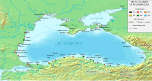
Periplus of the Euxine Sea


The Periplus of the Euxine Sea (Ancient Greek: Περίπλους τοῦ Εὐξείνου Πόντου, Períplous toû Euxeínou Póntou, modern Greek transliteration Períplous tou Efxínou Pódou, Latin: Periplus Ponti Euxini) is a periplus or guidebook detailing the destinations visitors encounter when traveling about the shore of the Black Sea. It was written by Arrian of Nicomedia from AD 130–131.[1]
Background
[edit]It is in the form of a letter, from Arrian to the Emperor Hadrian in Rome, who was particularly attached to geographical research and had visited in person a large portion of his extensive dominions. It contains an accurate topographical survey of the coasts of the Euxine (Black Sea), from Trapezus to Byzantium, and was written probably while Arrian held his office of legate of Cappadocia, a short time before war broke out against the Alani; and it was doubtless at the same time that he drew up his instructions for the march of the Roman army against the barbarians, which are found in a short but imperfect fragment annexed to the Techne Taktika, written, as he states himself, in the twentieth year of the reign of the emperor, and containing, after a brief account of former writers on the same subject, a description of the order and arrangement of an army in general.[2]
Its purpose was to inform the emperor of the "lay of the land" and provide him with necessary information such as the distances between cities and the locations that would provide safe harbor for ships in a storm in the eventuality that Hadrian should mount a military expedition to the region.[3]
The Periplus contains, according to Gibbon's epigrammatic expression in his 42nd chapter, "whatever the governor of Cappadocia had seen from Trebizond to Dioscurias; whatever he had heard, from Dioscurias to the Danube; and whatever he knew, from the Danube to Trebizond."[4] Thus, while Arrian gives much information upon the south and east side of the Euxine, in going round the north shore his intervals become greater, and his measurements less precise.[5]
Notes
[edit]- ^ "Arrianus". The New International Encyclopædia. Vol. II. New York: Dodd, Mead and Company. 1902. p. 44.
- ^ Rose, Hugh James; Rose, Henry John; Wright, Thomas (1848), A New General Biographical Dictionary, London: B. Fellowes, p. 207, OCLC 11837478.
- ^ Millar, Fergus (2004), Cotton, Hannah M.; Rogers, Guy M. (eds.), Rome, the Greek World, and the East vol. 2: Studies in the history of Greece and Rome, Chapel Hill: University of North Carolina Press, p. 183, ISBN 0-8078-5520-0, OCLC 46992203.
- ^ Gibbon, Edward, The History of the Decline and Fall of the Roman Empire
- ^ Smith, William (1854), A Dictionary of Greek and Roman Geography, London: Walton and Maberly, p. 887, ISBN 978-1-84511-001-7, OCLC 31406498.
References
[edit]- Rennell, James (1831), "An Examination of Arrian's Periplus of the Euxine Sea", A Treatise on the Comparative Geography of Western Asia, Accompanied with an Atlas of Maps, London: Printed for C.J.G. & F. Rivington: 271, OCLC 5621482.
See also
[edit]External links
[edit]- Hecataei Milesii fragmenta. Scylacis caryandensis periplus, Rudolf Heinrich Klausen (ed.), Berolini, impensis G. Reimeri, 1831, pp. 133-167.
- Geographi graeci minores, Karl Müller, Paris, editoribus Firmin-Didot et sociis, 1882, vol. 1 pp. 370-401.
- Text in Greek with French translation
- History of navigation
- 2nd-century books
- Travel guide books
- Geography books
- Works by Arrian
- Ancient Greek military books
- Roman-era Greek historiography
- Ancient Roman geography
- Correspondences
- Foreign relations of ancient Rome
- Roman itineraries
- Texts in Koine Greek
- 2nd century in international relations
- Ancient international relations
- Peripluses in Greek
- Black Sea
