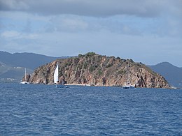
Pelican Island (British Virgin Islands)
 Pelican Island | |
 The location of Pelican Island within the British Virgin Islands | |
| Geography | |
|---|---|
| Location | Caribbean Sea |
| Coordinates | 18°19′57″N 64°37′31″W / 18.3326°N 64.6253°W |
| Archipelago | Virgin Islands |
| Administration | |
United Kingdom | |
| British Overseas Territory | British Virgin Islands |
| Demographics | |
| Population | 0 |
| Additional information | |
| Time zone | |
| ISO code | VG |
Pelican Island is an uninhabited island in the southwestern corner of the British Virgin Islands in the Caribbean. It is located immediately north of Norman Island, southwest of Peter Island. It is east of Flanagan Island in the southeastern corner of the US Virgin Islands.
The rocky cliffs on the south-western face of the island plunge into the sea, The National Park moorings make it a popular snorkeling and dive site. It is perfectly possible to land a boat on the other sides of the island, although there is not much to see.
In some older charts, Pelican Island is referred to as Witch Island, as is Flanagan Island. This confusion may be connected to a pre-1977 lack of clarification as to whether Flanagan formed part of the Danish (now US) islands, or the British Virgin Islands.


