Pathimoonnu Kannara Bridge
Appearance
Pathimoonnu Kannara Bridge | |
|---|---|
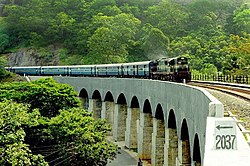
 View of the bridge after renovation | |
| Coordinates | 8°58′03″N 77°05′27″E / 8.96738°N 77.09084°E |
| Carries | Indian Railways |
| Crosses | valley in Kazhuthurutty |
| Other name(s) | 13 Arch Bridge |
| Characteristics | |
| Design | Arch bridge |
| Material | Rocks, limestone, and jaggery (Surki method) |
| Total length | 102.72 meters (337.0 ft) |
| Height | 5.18 meters (17.0 ft) |
| No. of spans | 13 |
| Rail characteristics | |
| No. of tracks | 1 |
| Track gauge | Broad gauge (5 ft 6 in) |
| History | |
| Construction start | 1900 |
| Construction end | 1903 |
| Inaugurated | 1904 |
| Location | |
 | |
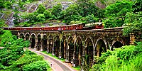
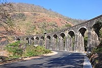
The Pathimoonnu Kannara Bridge, also called the "13 Arch Bridge", is a historic British-era structure on the Kollam-Sengottai railway line in India.[1][2][3] It is situated at Kazhuthurutty in the Kollam district of Kerala.[4] The bridge is a part of one of India's oldest mountain rail lines and was constructed by the British in 1904 to transport goods from Kollam to Madras.[5] The bridge was constructed with just rocks, limestone, and jaggery (Surki method), and it has 13 arches. The bridge, which connects two hillocks, is supported by thirteen granite pillars that are about 100 feet tall.[6] The bridge is sandwiched by the River Kazhuthurutti on one side and the Kollam Thirumangalam National Highway (NH 744) on the other.
Gallery
[edit]-
View of the bridge during monsoon (before renovation).
-
View of the bridge during summer (before renovation).
References
[edit]- ^ "The ancient heritage behind our railway bridges". Rediff.
- ^ "Thenmala, India's First Planned Eco-Tourism Destination Is Full of Scenic Surprises". The better India.
- ^ "Meter Gauge viaduct on the Quilon-Tenkasi line". Google Arts & Culture.
- ^ "Lesser Known Kerala Mountain Railways: Treat for Nature Lovers!". Be on the road.
- ^ "Vestibule between ages going out of view". The Hindu.
- ^ "New train to Chennai to cut travel by 3 hours". Deccan Chronicle.
Categories:
- Railway bridges in India
- Stone arch bridges
- Stone bridges
- Viaducts
- Bridges completed in 1904
- Transport infrastructure completed in 1904
- 1904 establishments in India
- 1904 establishments in British India
- Bridges in Kerala
- Rail transport in Kerala
- Buildings and structures in Kollam district
- Buildings and structures in Kollam


