Pasco Province
Appearance
Pasco Province | |
|---|---|
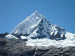
 Waqurunchu, one of the highest mountains of the Pasco Province | |
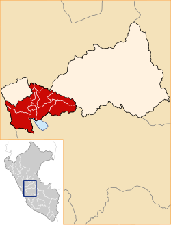
 Location of Pasco in the Pasco Region | |
| Country | Peru |
| Region | Pasco |
| Capital | Cerro de Pasco |
| Government | |
| • Mayor | Marco Antonio De la Cruz Bustillos (2019-2022) |
| Area | |
• Total | 4,758.57 km2 (1,837.29 sq mi) |
| Population | |
• Total | 123,015 |
| • Density | 26/km2 (67/sq mi) |
| UBIGEO | 1901 |
| Website | www |
The Pasco Province is one of the three provinces that make up the Pasco Region in Peru. The capital of this province is the city Cerro de Pasco.
Boundaries
[edit]- North: Huánuco Region
- East: Oxapampa Province
- South: Junín Region
- West: Lima Region, Daniel A. Carrión Province
Geography
[edit]The Waqurunchu mountain range traverses the province. One of the highest mountains of the province is Waqurunchu at 5,748 m (18,858 ft). Other mountain are listed below:[1]
- Anka Wachanan
- Añilqucha
- Awki
- Challwash
- Chuqimayu
- Hamp'atu
- Hatun Ukru
- Hatun Waqya
- Kasha Pata
- Kimaqucha
- Kiswar Mach'ay
- Kuchpanqa
- Kurawniyuq
- Luliqucha
- Luychu
- Luychuqucha
- Llama Lluchka
- Manka P'ukru
- Marayniyuq
- Millpu
- Mina Kasha
- Mishi Waqanan
- Muruqucha
- Ñat'iqucha
- Ñawsan
- Ñawsanqa
- Ñawsaqucha
- Pachapa Simin
- Parya Punta
- Pichqa Pukyu
- Pirwa Hirka
- Puka Uru
- Pukaqucha
- Puma Hirka
- Puma Wayin
- Putaqa
- Ranra Tampu
- Qaqa Mach'ay
- Qawi
- Qiwllaqucha
- Ranra Tampu
- Raqray
- Saqra Mach'ay
- Shaywa Punta
- Tampu Raqra
- Tawllish
- Tinyaqucha
- T'uru Hirka
- Uskhu Raqra
- Wachwa Rumi
- Wallqash Hanka
- Wank'a Wank'a
- Waqay Rumi
- Waqurunchu (Huá.-Pas.)
- Waraqu
- Warmi Chuku
- Waswas
- Waychaw Wachanan
- Wayrachina
- Yana Chaka
- Yana Chuku
- Yana K'uchu
- Yana Mach'ay
- Yanaqucha (Huachón)
- Yuraq Mit'u
Administrative division
[edit]The province has an area of 4,758.57 square kilometers (1,837.29 sq mi) and is divided into thirteen districts.
- Chaupimarca
- Huachón
- Huariaca
- Huayllay
- Ninacaca
- Pallanchacra
- Paucartambo
- San Francisco de Asís de Yarusyacán
- Simón Bolívar
- Ticlacayán
- Tinyahuarco
- Vicco
- Yanacancha
Population
[edit]The province has an approximate population of 123,015 inhabitants (2017).
See also
[edit]
|
10°41′24″S 76°16′12″W / 10.69000°S 76.27000°W
References
[edit]- ^ escale.minedu.gob.pe - UGEL map of the Pasco Province (Pasco Region)

