Pareh Sar District
Appearance
Pareh Sar District
Persian: بخش پرهسر | |
|---|---|
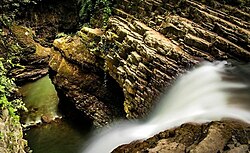
 Visadar Waterfall | |
| Coordinates: 37°32′05″N 48°54′36″E / 37.53472°N 48.91000°E[1] | |
| Country | Iran |
| Province | Gilan |
| County | Rezvanshahr |
| Capital | Pareh Sar |
| Population (2016)[2] | |
• Total | 28,251 |
| Time zone | UTC+3:30 (IRST) |
Pareh Sar District (Persian: بخش پرهسر) is in Rezvanshahr County, Gilan province, Iran. Its capital is the city of Pareh Sar.[3]
Demographics
[edit]Population
[edit]At the time of the 2006 National Census, the district's population wasAt the 2006 National Census, its population was 30,033 in 7,616 households.[4] The following census in 2011 counted 29,809 people in 8,538 households.[5] The 2016 census measured the population of the district as 28,251 inhabitants in 8,961 households.[2]
Administrative divisions
[edit]| Administrative Divisions | 2006[4] | 2011[5] | 2016[2] |
|---|---|---|---|
| Dinachal RD | 19,640 | 19,804 | 16,697 |
| Yeylaqi-ye Ardeh RD | 2,518 | 2,379 | 3,538 |
| Pareh Sar (city) | 7,875 | 7,626 | 8,016 |
| Total | 30,033 | 29,809 | 28,251 |
| RD = Rural District | |||
See also
[edit]References
[edit]- ^ OpenStreetMap contributors (14 October 2024). "Pareh Sar District (Rezvanshahr County)" (Map). OpenStreetMap (in Persian). Retrieved 14 October 2024.
- ^ a b c Census of the Islamic Republic of Iran, 1395 (2016): Gilan Province. amar.org.ir (Report) (in Persian). The Statistical Center of Iran. Archived from the original (Excel) on 4 December 2020. Retrieved 19 December 2022.
- ^ Habibi, Hassan (c. 2023) [Approved 24 February 1376]. Carrying out divisional reforms in Gilan province. lamtakam.com (Report) (in Persian). Ministry of the Interior, Political-Defense Commission of the Government Council. Proposal 1.4.42.14642; Letter 93808-907. Archived from the original on 13 December 2023. Retrieved 13 December 2023 – via Lam ta Kam.
- ^ a b Census of the Islamic Republic of Iran, 1385 (2006): Gilan Province. amar.org.ir (Report) (in Persian). The Statistical Center of Iran. Archived from the original (Excel) on 20 September 2011. Retrieved 25 September 2022.
- ^ a b Census of the Islamic Republic of Iran, 1390 (2011): Gilan Province. irandataportal.syr.edu (Report) (in Persian). The Statistical Center of Iran. Archived from the original (Excel) on 8 October 2023. Retrieved 19 December 2022 – via Iran Data Portal, Syracuse University.


