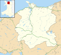
Pandy Tudur
| Pandy Tudur | |
|---|---|
 Pandy Tudur church | |
Location within Conwy | |
| OS grid reference | SH857642 |
| Community | |
| Principal area | |
| Country | Wales |
| Sovereign state | United Kingdom |
| Post town | ABERGELE |
| Postcode district | LL22 |
| Dialling code | 01745 |
| Police | North Wales |
| Fire | North Wales |
| Ambulance | Welsh |
| UK Parliament | |
| Senedd Cymru – Welsh Parliament | |
Pandy Tudur is a village in Conwy county borough, in the north-west of Wales. It lies 5 miles northeast of Llanrwst.
Origins of the name
[edit]The name was originally Pandybudr, from the Welsh pandy ('fulling mill') and budr ('dirty'). The meaning 'dirty fulling-mill' was considered unattractive and the adjective budr was replaced in Victorian times by the personal name Tudur, thus giving Pandytudur (supposedly 'Tudur's fulling mill').[1]
Language
[edit]At the time of the 2001 UK Census, 55.5% of the population spoke the Welsh language. The highest percentage of speakers was within the 5-9 age group, where 71.1% could speak the language. Children in the village mostly attend a small Welsh-medium primary school in the nearby village of Llangernyw.
Facilities
[edit]The village has a chapel of the Presbyterian Church of Wales.
Nearby lie the turbines of Moel Maelogan wind farm.
References
[edit]- ^ Owen, Hywel Wyn; Morgan, Richard (2007). Dictionary of the place-names of Wales. Llandysul: Gomer. p. 358. ISBN 978-1-84323-901-7. OCLC 191731809.
External links
[edit]![]() Media related to Pandy Tudur at Wikimedia Commons
Media related to Pandy Tudur at Wikimedia Commons


