Pajarito Mountains (Sonora)
Appearance
| Pajarito Mountains | |
|---|---|
| Naming | |
| Native name | Sierra El Pajarito (Spanish) |
| Geography | |
| Country | Mexico |
| State | Sonora |
| Region | northwestern Mexico |
| Range coordinates | 29°23′15″N 110°07′19″W / 29.38750°N 110.12194°W |
| Parent range | Sierra Madre Occidental |
| Topo map | NH12-08 |
| Geology | |
| Orogeny | Laramide |
| Rock type | Volcanic |
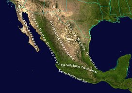
The Pajarito Mountains (Sierra El Pajarito,[1] Sierra Pajapitos[2]) are a small mountain range in the Sierra Madre Occidental. They are located in the state of Sonora in northwestern Mexico.
Geography
[edit]To the north are the El Jaralito Mountains, between them and the Pajaritos is the Ures River (Río Ures).[3]
Notes and references
[edit]- ^ Sierra El Pajarito (Approved - N) at GEOnet Names Server, United States National Geospatial-Intelligence Agency
- ^ Sierra Pajapitos (Variant - V) at GEOnet Names Server, United States National Geospatial-Intelligence Agency
- ^ Roldán-Quintana, Jaime; Lozano-Santacruz, Rufino; Arrazolo-Reyna, Sonia (1989). "Pegmatitas de la sierra El Jaralito al suroeste de Baviácora, Sonora" (PDF). Revista Mexicana de Ciencias Geológicas (in Spanish). 8 (1): 15–21. Archived (PDF) from the original on 12 August 2018.

