Pa'ar Cave
Appearance
| Pa'ar Cave Nature Reserve | |
|---|---|
| מערת פער | |
 Pa'ar Cave | |
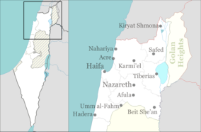
| Location | Upper Galilee, Israel |
| Nearest city | Sasa |
| Coordinates | 33°1′51.63″N 35°23′9.28″E / 33.0310083°N 35.3859111°E |
| Area | 14 dunams (0.014 km2; 0.0054 sq mi) |
| Established | 1967 |
| Governing body | Israel Nature and Parks Authority |
Pa'ar Cave (Hebrew: מערת פער) is a karstic sinkhole in the Upper Galilee, Israel.
History
[edit]The cave is located between the Adir peak (part of the Meron range), and kibbutz Sasa. The sinkhole channels the water flowing from the Pa'ar stream to groundwater level.
The cave is part of a 14-dunam nature reserve, declared in 1967, that bears its name.[1] The reserve is home to Palestine Oak (Quercus calliprinos) and Quercus infectoria oak trees, Hawthorn trees (Crataegus azarolus aronia), Dog Rose (Rosa canina) bushes, and Sternbergia bulb flowers.[2]
See also
[edit]References
[edit]- ^ "List of National Parks and Nature Reserves" (PDF) (in Hebrew). Israel Nature and Parks Authority. Archived from the original (PDF) on 2009-10-07. Retrieved 2010-09-27.
- ^ "Pa'ar Cave Nature Reserve" (in Hebrew). iNature.info. Retrieved 2010-10-03.
External links
[edit]- "The Pa'ar Cave near Sasa" (in Hebrew). Ynet.co.il. Retrieved 2010-10-03.
- Photos from the Reserve

