Pątnów, Lower Silesian Voivodeship
Appearance
Pątnów | |
|---|---|
Village | |
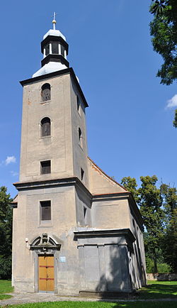
 Saint John the Baptist church in Pątnów | |
| Coordinates: 51°14′N 16°0′E / 51.233°N 16.000°E | |
| Country | |
| Voivodeship | Lower Silesian |
| County | Legnica |
| Gmina | Chojnów |
| Time zone | UTC+1 (CET) |
| • Summer (DST) | UTC+2 (CEST) |
| Vehicle registration | DLE |
Pątnów [ˈpɔntnuf] is a village in the administrative district of Gmina Chojnów, within Legnica County, Lower Silesian Voivodeship, in south-western Poland.[1] It lies approximately 6 kilometres (4 mi) south-east of Chojnów, 12 km (7 mi) west of Legnica, and 74 km (46 mi) west of the regional capital Wrocław.
The village was surely known by 1277, and was mentioned in the medieval Chronica principum Poloniae.[2]
Transport
[edit]The A4 motorway runs nearby, southwest of the village, and the National road 94 passes nearby, north of the village.
References
[edit]- ^ "Central Statistical Office (GUS) – TERYT (National Register of Territorial Land Apportionment Journal)" (in Polish). 2008-06-01.
- ^ Słownik geograficzny Królestwa Polskiego i innych krajów słowiańskich, Tom VII (in Polish). Warsaw. 1886. p. 929.
{{cite book}}: CS1 maint: location missing publisher (link)

