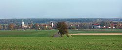
Pötzschau
Appearance
Pötzschau | |
|---|---|
 Pötzschau from the south-west | |
| Coordinates: 51°12′40″N 12°29′06″E / 51.21114°N 12.48503°E | |
| Country | Germany |
| State | Saxony |
| Town | Rötha |
| Elevation | 131 m (430 ft) |
| Population (2014-12-31) | |
• Total | 374 |
| Time zone | UTC+01:00 (CET) |
| • Summer (DST) | UTC+02:00 (CEST) |
| Postal codes | 04579 |
| Dialling codes | 034347 |
Pötzschau is a village and a former municipality in Saxony, Germany. Since 2015, it has been part of the town of Rötha. It consists of the smaller parts, Großpötzschau, Kleinpötzschau, and Dahlitzsch. Pötzschau is south-east of Leipzig in the valley of the creek Gösel.
History
[edit]
The first mention was as Beschowe in 1206, the distinction was added, "Groß" (great) in 1514, and "Klein" (small) in 1497. Dahlitzsch was first mentioned as Talzschicz in 1469.[1] Formerly an independent municipality, it was merged into the municipality of Espenhain in 1995.[2] Espenhain was merged into the town of Rötha in 2015.[3]
References
[edit]- ^ Digitales Historisches Ortsverzeichnis von Sachsen
- ^ Pötzschau in the Digital Historic Index of Places in Saxony (Digitales Historisches Ortsverzeichnis von Sachsen)
- ^ Gebietsänderungen von Januar bis Dezember 2015, Statistisches Bundesamt
Literature
[edit]- Thomas Nabert, Andreas Berkner, Sigrun Kabisch (ed.): Im Pleiße- und Göselland : zwischen Markkleeberg, Rötha und Kitzscher, ProLeipzig, Leipzig 1999, ISBN 3-9806474-1-2
- Richard Steche: Kleinpötzschau. In: Beschreibende Darstellung der älteren Bau- und Kunstdenkmäler des Königreichs Sachsen, 15. Volume: Amtshauptmannschaft Borna. C. C. Meinhold, Dresden, 1891, p. 65.


