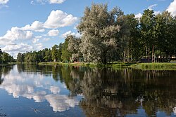
Põltsamaa (river)
Appearance
| Põltsamaa | |
|---|---|
 | |
 | |
| Location | |
| Country | Estonia |
| Region | Jõgeva County, Järva County, and Lääne-Viru County |
| Physical characteristics | |
| Mouth | Pedja River |
• coordinates | 58°26′41″N 26°09′46″E / 58.44483°N 26.16270°E |
| Length | 135 km (84 mi) |
| Basin features | |
| Tributaries | |
| • right | Preedi |
The Põltsamaa is the third-longest river in Estonia. It flows through Põltsamaa Parish and the centre of the town of Põltsamaa on the northeast side of Põltsamaa Castle.[1] It is a tributary of the Pedja.
References
[edit]- ^ "Põltsamaa Castle - Magnets - South-Estonia". Southestonia.ee. Archived from the original on 2013-11-09. Retrieved 2013-06-08.
External links
[edit]Wikimedia Commons has media related to Põltsamaa.
