Outline of West Bengal
Appearance

The following outline is provided as an overview of and topical guide to West Bengal:
West Bengal – state in eastern India and is the nation's fourth-most populous state, with over 91 million inhabitants. Spread over 34,267 sq mi (88,750 km2), it is bordered by the countries of Bangladesh, Nepal and Bhutan, and the Indian states of Odisha, Jharkhand, Bihar, Sikkim and Assam. The state capital is Kolkata (Calcutta), one of the largest cities in India. Together with the neighbouring nation of Bangladesh, it makes up the ethno-linguistic region of Bengal.
General reference
[edit]Names
[edit]- Common name: West Bengal
- Pronunciation:
- Local name: Paschim Bongo পশ্চিম বঙ্গ
- Abbreviations and name codes
- Nicknames
- Adjectivals
Rankings (amongst India's states)
[edit]- by population: 4th
- by area (2011 census): 14th
- by crime rate (2015): 17th
- by gross domestic product (GDP) (2014): 4th
- by Human Development Index (HDI): 11th
- by life expectancy at birth:
- by literacy rate (2011):76.62%
Geography of West Bengal
[edit]- West Bengal is: an Indian state
- Population of West Bengal:
- Area of West Bengal: 88,750 km2
- Atlas of West Bengal
Location of West Bengal
[edit]- West Bengal is situated within the following regions:
- Time zone: Indian Standard Time (UTC+05:30)
Environment of West Bengal
[edit]


Natural geographic features of West Bengal
[edit]Regions of West Bengal
[edit]Ecoregions of West Bengal
[edit]Administrative divisions of West Bengal
[edit]Capital of West Bengal
[edit]Divisions of West Bengal
[edit]Districts of West Bengal
[edit]
- Alipurduar district
- Bankura
- purba Bardhaman
- Paschim Bardhaman
- Birbhum
- Cooch Behar
- Darjeeling
- kalimpong
- East Midnapore
- Hooghly
- Howrah
- Jalpaiguri
- Kolkata
- Malda
- Murshidabad
- Nadia
- North 24 Parganas (Largest in terms of population and population density)
- Uttar Dinajpur
- Purulia
- South 24 Parganas (Largest in terms of area)
- Dakshin Dinajpur
- Jhargram
- West Midnapore
Cities of West Bengal
[edit]Demography of West Bengal
[edit]Government and politics of West Bengal
[edit]- Form of government: Indian state government (parliamentary system of representative democracy)
- Capital of West Bengal: Kolkata
- Elections in West Bengal
- (specific elections)
Union government in West Bengal
[edit]- Rajya Sabha members from West Bengal
- 2009 Indian general election in West Bengal
- 2014 Indian general election in West Bengal
- 2019 Indian general election in West Bengal
- 2024 Indian general election in West Bengal
Branches of the government of West Bengal
[edit]Executive branch of the government of West Bengal
[edit]- Head of state: Governor of West Bengal
- Head of government: Chief Minister of West Bengal
- Council of Ministers of West Bengal
Legislative branch of the government of West Bengal
[edit]West Bengal Legislative Assembly
Judicial branch of the government of West Bengal
[edit]Law and order in West Bengal
[edit]History of West Bengal
[edit]History of West Bengal, by period
[edit]Prehistoric West Bengal
[edit]Ancient West Bengal
[edit]Medieval West Bengal
[edit]Colonial West Bengal
[edit]Contemporary West Bengal
[edit]History of West Bengal, by region
[edit]History of West Bengal, by subject
[edit]Culture of West Bengal
[edit]- Architecture of West Bengal
- Cuisine of West Bengal
- Languages of West Bengal
- Monuments in West Bengal
- World Heritage Sites in West Bengal
Art in West Bengal
[edit]People of West Bengal
[edit]Religion in West Bengal
[edit]Sports in West Bengal
[edit]Symbols of West Bengal
[edit]


- State animal: Fishing cat
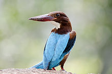
- State bird: White-throated kingfisher

- State flower: Night-flowering jasmine
- State seal: Seal of West Bengal
- State tree: Devil tree
- Union Day: August 18 ( Day of accession to India )

