Oropesa, Spain
Appearance
Oropesa | |
|---|---|
 | |
| Coordinates: 39°55′N 5°11′W / 39.917°N 5.183°W | |
| Country | |
| Autonomous community | |
| Province | Toledo |
| Comarca | Campana de Oropesa |
| Judicial district | Talavera de la Reina |
| Government | |
| • Alcalde | Juan Antonio Morcillo Reviriego (2007) |
| Area | |
• Total | 337 km2 (130 sq mi) |
| Elevation | 425 m (1,394 ft) |
| Population (2018)[1] | |
• Total | 2,658 |
| • Density | 7.9/km2 (20/sq mi) |
| Demonym(s) | Oropesano, na |
| Time zone | UTC+1 (CET) |
| • Summer (DST) | UTC+2 (CEST) |
| Postal code | 45560 |
| Dialing code | 925 |
| Official language(s) | Castillian |
| Website | Official website |
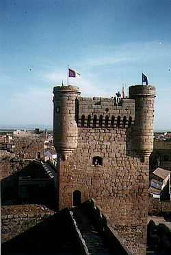
Oropesa (Spanish: [oɾoˈpesa] ) is a Spanish town in the province of Toledo. The town of 2,872 is famous for its castle, which was built in 1402, turned into a Parador Nacional — the Parador de Oropesa — in 1930. The castle was formerly the residence of the Toledo family of nobles. This includes Francisco de Toledo, Count of Oropesa, who became the Viceroy of Peru.
The town has a yearly celebration in April called "Jornadas Medievales", or "Medieval Days", which plays off the presence of the Castle in Oropesa.
Etymology
[edit]The place name Oropesa is of very ancient origin, which makes it difficult to indicate its origin and motivation. The most accepted idea is its origin from the pre-Roman place name Otobesa.[2]
References
[edit]- ^ Municipal Register of Spain 2018. National Statistics Institute.
- ^ García Sánchez 1998, pp. 97–99.
See also
[edit]


