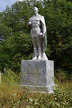
Orlivka, Ocheretyne settlement hromada, Pokrovsk Raion, Donetsk Oblast
Appearance
Orlivka
Орлівка | |
|---|---|
Village | |
 Monument in Orlivka | |
| Coordinates: 48°09′45″N 37°38′14″E / 48.16250°N 37.63722°E | |
| Country | |
| Oblast | |
| Raion | |
| Hromada | Ocheretyne settlement hromada |
| Founded | 1847 |
| Elevation | 195 m (640 ft) |
| Population | |
• Total | 874 |
| Time zone | UTC+2 (EET) |
| • Summer (DST) | UTC+3 (EEST) |
| Postal code | 86050 |
| Area code | +380 6236 |
| KOATUU code | 14160190210082037 |
 | |
Orlivka (Ukrainian: Орлівка, [orˈl⁽ʲ⁾iu̯kɐ]) is a village in Ocheretyne settlement hromada, Pokrovsk Raion, Donetsk Oblast, Ukraine.
History
[edit]Russo-Ukrainian War
[edit]Russian invasion of Ukraine
[edit]During the Russian invasion of Ukraine, Orlivka has been the site of fighting since the end of the battle of Avdiivka in February 2024.[2] On 19 March, Russia took over control of the village as the Ukrainian Armed Forces left the village.[3]
Demographics
[edit]As of the 2001 Ukrainian census, the settlement had 874 inhabitants. Their native languages were 25.71% Ukrainian, 74.14% Russian, 0.11% Belarusian and Moldovan (Romanian).[1]
References
[edit]- ^ a b "All-Ukrainian population census". db.ukrcensus.gov.ua. State Statistics Service of Ukraine. Retrieved 29 February 2024.
- ^ "Syrskyi visits front line, reports Russian offensive at Orlivka held back". kyivindependent.com. The Kyiv Independent. 29 February 2024. Retrieved 29 February 2024.
- ^ "Russia Claims New Advances in East as Kyiv Awaits Western Support". The Moscow Times. 19 March 2024. Retrieved 19 March 2024.


