Ohio State Route 284
 | ||||
| Route information | ||||
| Maintained by ODOT | ||||
| Length | 17.41 mi[1] (28.02 km) | |||
| Existed | 1930–present | |||
| Major junctions | ||||
| South end | ||||
| North end | ||||
| Location | ||||
| Country | United States | |||
| State | Ohio | |||
| Counties | Morgan, Muskingum | |||
| Highway system | ||||
| ||||
| ||||
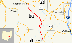
State Route 284 (SR 284, OH 284) is a north–south state highway in east central Ohio, a U.S. state. State Route 284 has its southern terminus is at State Route 83 approximately 8 miles (13 km) northeast of McConnelsville, and just 0.25 miles (0.40 km) north of the western split of the concurrency State Route 83 has with State Route 78. The northern terminus of State Route 284 is at a T-intersection with State Route 146 in the unincorporated community of Chandlersville. A portion of SR 284 is part of the Morgan County Scenic Byway.[citation needed]
Route description
[edit]State Route 284 runs through portions of Morgan and Muskingum Counties. No portion of this state highway is included within the National Highway System.[2]
This section needs expansion. You can help by adding to it. (May 2011) |
History
[edit]The year 1930 marked the debut of State Route 284 in the Ohio state highway system. Routed at inception along the path that it currently occupies, State Route 284 has not experienced any significant changes.[3][4]
Major intersections
[edit]| County | Location | mi[1] | km | Destinations | Notes |
|---|---|---|---|---|---|
| Morgan | Bristol Township | 0.00 | 0.00 | ||
| Muskingum | Meigs Township | 7.71 | 12.41 | Western terminus of SR 340 | |
| Salt Creek Township | 17.41 | 28.02 | |||
| 1.000 mi = 1.609 km; 1.000 km = 0.621 mi | |||||
References
[edit]- ^ a b Ohio Department of Transportation. "Technical Services Straight Line Diagrams". Retrieved 2010-08-20.
- ^ National Highway System: Ohio (PDF) (Map). Federal Highway Administration. December 2003. Archived from the original (PDF) on October 16, 2008. Retrieved 2010-08-20.
- ^ Ohio State Map (Map). Ohio Department of Transportation. 1929.
- ^ Ohio State Map (Map). Ohio Department of Transportation. 1930.

