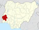
Ogbomosho South
Ogbomoso South | |
|---|---|
 | |
| Country | |
| State | Oyo State |
| Government | |
| • Local Government Chairman and the Head of the Local Government Council | Oyeniyi Timothy Oyedokun (PDP) Traditional ruler Onijeru of ijeruland |
| Time zone | UTC+1 (WAT) |
| Website | ogbomoshosouth |
 | |
Ogbomoso South local government government area is domiciled in Oyo state, South-west geopolitical zone of Nigeria. Its headquarters are located in Arowomole area of Ogbomoso.
History
[edit]Ogbomoso South Local Government Area was established in 1991, carved out from the former Ogbomoso Local Council.[1] The Yoruba language is the dominant language in the Area, and the residents widely adhere to the religions of Christianity and Islam among the population.[1]
Population/Area
[edit]It has an area of 88 km2 and a population of 185,815 at the 2006 census.
Office postal code
[edit]The postal code of the area is 210101.[2][3]
History
[edit]Ogbomoso South Local Government was formed in 1991 from the previous Ogbomoso Local Government by the Military Administration. Neighbourhoods in the Council include Idi- igba, Gaa- Lagbedu, Kajola, Kowe, Oke- Ola, Adeoye, Onidewure, Molete, Arowomole, Sanuaje, Obandi, Ijeru, Ayegun, and Oke Alapata.[4]
Economy
[edit]The economic of Ogbomosho South Local Government Area primarily relies on agriculture. The region possesses fertile land, and farming serves as the primary livelihood for its residents.
Ogbomoso South Local Government Area boasts a flourishing trade sector, featuring various markets, including the popular Aarada market where a diverse range of commodities is traded. Agriculture thrives in the region, with the cultivation of crops like cocoa, rice, cassava, and melon. The people of Ogbomoso South Local Government Area engage in important economic activities such as hunting, textile weaving and dyeing, and crafting.[1]
Geography
[edit]Ogbomoso South Local Government Area spans approximately 68 square kilometres, experiencing an average temperature of 28 degrees Celsius. The annual precipitation in Ogbomoso South Local Government Area is around 1830 mm, with an average wind speed recorded at 9 km/h.[1]
Locality
[edit]Town and Villages under Ogbomosho North Local Government Area:[1]
- Adeoye
- Arowomole
- Gaa Legbedu
- Obandi
- Kajola
- Oke Alapata
- Oke ola
- Onidewure
- Oke-Oba
- Ore-Merin
Popular Places
[edit]State Hospital Complex – Sodiq Sekendegbe Street, Arowomole
Secretariat Complex – Arowomole
The Apostolic Church, Alapata Assembly[5]
National Museum, Arowomole
Nigerian Baptist Theological Seminary
Beulah Baptist Centre
State Library – Arowomole
Federal Housing Estate – Ibapon Road
Industrial Estate – Osogbo Road
Idi-Oro Baptist Church
Akande Market – Caretaker
DAD Foundation Sports Arena, Idi-Oro
Federal Road Safety Corps – Oluwatedo
Maryland Catholic High School
Methodist Cathedral – Arowomole
Berean Independent Baptist Church – Kajola
St Anne Catholic Church – Arinkinkin
St Ferdinand Catholic Church
Onpetu of Ijeru Palace
Government Technical college, Kajola[6]
Baptist Secondary Grammar School, Ahoyaya.
The Apostolic Primary School II
Abede Primary School[4]
The Apostolic Model School
Aarada Market – Osogbo Road
Ayegun Primary School II
A.U.D Primary School, Awoye Street.
Kajola Primary School
References
[edit]- ^ a b c d e "Ogbomoso South Local Government Area". www.manpower.com.ng. Retrieved 2023-12-30.
- ^ "Post Offices- with map of LGA". NIPOST. Archived from the original on November 26, 2012. Retrieved 2009-10-20.
- ^ "Ogbomoso South LGA Postal Code". ZIP Code. Retrieved 2023-12-04.
- ^ a b "OGBOMOSO SOUTH LOCAL GOVERNMENT – Oyo State Government". Retrieved 2022-03-05.
- ^ "The Apostolic Church Nigeria, Alapata Assembly, Ogbomoso. 🇳🇬 - WorldPlaces". nigeria.worldplaces.me. Retrieved 2022-03-05.
- ^ "State Technical Colleges in Kajola, Oyo State".

