Oblivskaya
Oblivskaya
Обливская | |
|---|---|
 | |
| Coordinates: 48°32′12″N 42°29′39″E / 48.53667°N 42.49417°E | |
| Country | Russia |
| Federal subject | Rostov Oblast[1] |
| Administrative district | Oblivsky District[1] |
| Founded | 1744 |
| Population | |
| • Total | 9,908 |
| Time zone | UTC+3 (MSK |
| Postal code(s)[3] | 347141 |
| OKTMO ID | 60640420101 |
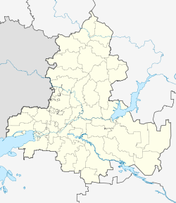
Oblivskaya (Russian: Обливская) is a rural locality (a stanitsa) in Oblivsky District of Rostov Oblast, Russia. Population: 9,908 (2010 Census);[1] 9,543 (2002 Census).[4] It is also the administrative center of Oblivsky District.
History
[edit]
It is believed that the khutor of Oblivy was first settled by cossacks in 1744. In 1838 the settlement had 42 households.
The original territory of the khutor was surrounded by Chir River and several lakes. In spring, during the floods, the territory of the farm was fenced off from the land with water, and sometimes the village itself used to become flooded. Over time the village was moved up to the hill. As of 1879, there were 80 households there.
In the 1860s, a Chapel was built here and later a parish school began to function, in which natural sciences, handicrafts, exact sciences, French and German languages were taught. In 1881 a post office was established in the village.[5]
Before Russian Revolution of 1917 the stanitsa had a population of about 1500 people.
Oblivskaya was the site of hostilities in World War II.[6] It was briefly occupied by Germans and later liberated on 31 December 1942.[7]
Places of interest
[edit]- Museum of local history
- St. Nicholas' Church, an architectural monument of the 19th century and an object of cultural heritage of Russia.
References
[edit]- ^ a b c d e f Russian Federal State Statistics Service (2011). Всероссийская перепись населения 2010 года. Том 1 [2010 All-Russian Population Census, vol. 1]. Всероссийская перепись населения 2010 года [2010 All-Russia Population Census] (in Russian). Federal State Statistics Service.
- ^ "Об исчислении времени". Официальный интернет-портал правовой информации (in Russian). 3 June 2011. Retrieved 19 January 2019.
- ^ Почта России. Информационно-вычислительный центр ОАСУ РПО. (Russian Post). Поиск объектов почтовой связи (Postal Objects Search) (in Russian)
- ^ Federal State Statistics Service (21 May 2004). Численность населения России, субъектов Российской Федерации в составе федеральных округов, районов, городских поселений, сельских населённых пунктов – районных центров и сельских населённых пунктов с населением 3 тысячи и более человек [Population of Russia, Its Federal Districts, Federal Subjects, Districts, Urban Localities, Rural Localities—Administrative Centers, and Rural Localities with Population of Over 3,000] (XLS). Всероссийская перепись населения 2002 года [All-Russia Population Census of 2002] (in Russian).
- ^ "Администрация Обливского района Ростовской области". www.oblivsk.ru. Retrieved 2017-10-11.
- ^ ВОВ-60 − оперативные сводки
- ^ День Победы: Война, фронтовые сводки за 31 декабря 1942 года


