Ngake
Appearance

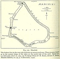
Ngake is one of 43 islands in the Manihiki atoll of the Cook Islands.[1] It is the largest island, making up almost the entire north-eastern side of the atoll. The village of Tukao and Manihiki Island Airport are both located on the island.
References
[edit]- ^ Te Rangi Hiroa (1932). Ethnology of Manihiki and Rakahanga. Honolulu: Bernice P. Bishop Museum. p. 6. Retrieved 13 August 2020.
10°22′50″S 160°59′59″W / 10.38056°S 160.99972°W
