New Fryston

New Fryston is a small former coal mining village in Castleford, West Yorkshire, England, located in a river bend on the south bank of the River Aire.[1]

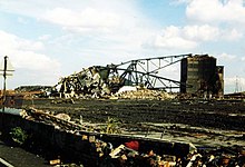
The colliery opened in the 1870s in the grounds of the now-demolished Fryston Hall and was named Fryston, and the village was built in the 1880s to house some of the miners.[2][3] At its peak, the pit employed around 1,300 miners.[3] It closed in 1985.[2] After the pit's closure, the colliery buildings were demolished.[3]
The settlement is also called Fryston village.[2]
In 2005, a re-generation programme called the Castleford Project, carried out a number of re-developments in Fryston including what turned out to be a controversial new Village Green; these re-developments were the subject of a series of television programmes on Channel 4.[3][4]
See also
[edit]References
[edit]- ^ Yorkshire CCXXXIV.NE (includes: Castleford; Fairburn; Garforth; Ledsham; Ledston.) (Map). Ordnance Survey. 1893.
- ^ a b c "Castleford History". www.castleford.org. Retrieved 12 March 2016.
- ^ a b c d McClarence, Stephen (4 June 2012). "Homeward Bound". Yorkshire Post. Retrieved 12 March 2016.
- ^ "Kevin McCloud and the Big Town Plan". www.channel4.com. Retrieved 12 March 2016.
External links
[edit] Media related to New Fryston at Wikimedia Commons
53°44′19″N 1°18′48″W / 53.738722°N 1.313343°W
