Neshanic Mills
Appearance
Neshanic Mills | |
 Lane Grist Mill on the South Branch Raritan River | |
| Location | River Road and Mill Lane, Neshanic Station, New Jersey |
|---|---|
| Coordinates | 40°30′31″N 74°43′33″W / 40.50861°N 74.72583°W |
| Area | 5 acres (2.0 ha) |
| NRHP reference No. | 78001797[1] |
| NJRHP No. | 2524[2] |
| Significant dates | |
| Added to NRHP | January 9, 1978 |
| Designated NJRHP | June 13, 1977 |
Neshanic Mills is a 5-acre (2.0 ha) historic district on the South Branch Raritan River along River Road and Mill Lane at Neshanic Station in Somerset County, New Jersey, United States. The district was added to the National Register of Historic Places on January 9, 1978, for its significance in engineering, industry, transportation, and settlement. It includes 4 contributing buildings and 2 contributing structures.[3]
History and description
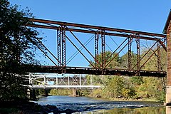
[edit]The three-story Lane Grist Mill was constructed in 1876 by Andrew Lane. The Neshanic Station Lenticular Truss Bridge was constructed by the Berlin Iron Bridge Co. in 1896. The Central Railroad of New Jersey bridge was built around 1900.[3]
Gallery of contributing properties
[edit]-
Lane Grist Mill
-
Abandoned railroad bridge, Through Pratt Truss
References
[edit]- ^ "National Register Information System – (#78001797)". National Register of Historic Places. National Park Service. November 2, 2013.
- ^ "New Jersey and National Registers of Historic Places – Somerset County" (PDF). New Jersey Department of Environmental Protection – Historic Preservation Office. September 11, 2023. p. 9.
- ^ a b McCabe, Wayne T. (June 1977). "National Register of Historic Places Inventory/Nomination: Neshanic Mills". National Park Service. With accompanying 9 photos
External links
[edit] Media related to Neshanic Mills at Wikimedia Commons
Categories:
- Hillsborough Township, New Jersey
- Branchburg, New Jersey
- National Register of Historic Places in Somerset County, New Jersey
- Historic districts on the National Register of Historic Places in New Jersey
- Grinding mills on the National Register of Historic Places in New Jersey
- New Jersey Register of Historic Places
- Buildings and structures in Somerset County, New Jersey


