From Wikipedia, the free encyclopedia
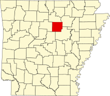
Location of Cleburne County in Arkansas This is a list of the National Register of Historic Places listings in Cleburne County, Arkansas .
This is intended to be a complete list of the properties and districts on the National Register of Historic Places in Cleburne County , Arkansas , United States . The locations of National Register properties and districts for which the latitude and longitude coordinates are included below, may be seen in a map.[ 1]
There are 18 properties and districts listed on the National Register in the county.
Contents: Counties in Arkansas
This National Park Service list is complete through NPS recent listings posted November 8, 2024. [ 2]
[ 3] Name on the Register[ 4]
Image
Date listed[ 5]
Location
City or town
Description
1
Brewer School Brewer School May 26, 2004 (#04000506 ) Brewer Rd. 35°40′09″N 92°10′57″W / 35.669167°N 92.1825°W / 35.669167; -92.1825 (Brewer School ) Brewer
2
Cleburne County Courthouse Cleburne County Courthouse July 12, 1976 (#76000393 ) Courthouse Sq. 35°29′27″N 92°01′55″W / 35.490833°N 92.031944°W / 35.490833; -92.031944 (Cleburne County Courthouse ) Heber Springs
3
Cleburne County Farm Cemetery Cleburne County Farm Cemetery September 28, 2005 (#05001066 ) Southeastern corner of the junction of Plantation Dr., E., and Deer Run 35°27′20″N 92°02′15″W / 35.455556°N 92.0375°W / 35.455556; -92.0375 (Cleburne County Farm Cemetery ) Heber Springs
4
Dr. Cyrus F. Crosby House Dr. Cyrus F. Crosby House November 19, 1993 (#93001258 ) 202 N. Broadway St. 35°29′33″N 92°01′40″W / 35.4925°N 92.027778°W / 35.4925; -92.027778 (Dr. Cyrus F. Crosby House ) Heber Springs
5
Dill School Dill School August 16, 1994 (#94000854 ) Western side of Highways 5 and 25 , north of Ida 35°35′39″N 91°55′59″W / 35.594167°N 91.933056°W / 35.594167; -91.933056 (Dill School ) Ida
6
Mike Meyer Disfarmer Gravesite Mike Meyer Disfarmer Gravesite January 21, 2009 (#08001335 ) In the Heber Springs Cemetery at the northeastern corner of Oak St. and S. 4th St. 35°29′00″N 92°02′01″W / 35.483333°N 92.033611°W / 35.483333; -92.033611 (Mike Meyer Disfarmer Gravesite ) Heber Springs
7
Clarence Frauenthal House Clarence Frauenthal House November 19, 1993 (#93001256 ) 210 N. Broadway St. 35°29′36″N 92°01′40″W / 35.493333°N 92.027778°W / 35.493333; -92.027778 (Clarence Frauenthal House ) Heber Springs
8
O.D. Gunn Trade and Sale Barn O.D. Gunn Trade and Sale Barn June 7, 2016 (#16000316 ) 10 Anna St. 35°22′59″N 92°12′58″W / 35.383068°N 92.216137°W / 35.383068; -92.216137 (O.D. Gunn Trade and Sale Barn ) Quitman
9
Heber Springs Commercial Historic District Heber Springs Commercial Historic District May 1, 2009 (#09000266 ) 100 and 200 blocks of E. Main St., 100-500 blocks of W. Main St., 100 block of N. and S. 3rd, and N. and S. 4th Sts. 35°29′29″N 92°01′46″W / 35.491461°N 92.029567°W / 35.491461; -92.029567 (Heber Springs Commercial Historic District ) Heber Springs
10
Hugh L. King House Hugh L. King House September 8, 1992 (#92001224 ) 110 W. Spring St. 35°29′34″N 92°01′47″W / 35.492778°N 92.029722°W / 35.492778; -92.029722 (Hugh L. King House ) Heber Springs
11
Martin Dipping Vat Upload image May 9, 2022 (#100007717 ) Southeast of the intersection of Tiger B and Gills Rds. 35°38′21″N 91°51′49″W / 35.6392°N 91.8635°W / 35.6392; -91.8635 (Martin Dipping Vat ) Concord vicinity
12
Old Highway 16 Bridge Old Highway 16 Bridge May 11, 2011 (#11000262 ) Lakefront Resort Rd. 35°36′09″N 92°11′18″W / 35.6025°N 92.188333°W / 35.6025; -92.188333 (Old Highway 16 Bridge ) Edgemont vicinity
13
T.E. Olmstead & Son Funeral Home T.E. Olmstead & Son Funeral Home December 13, 1995 (#95001438 ) 108 S. 4th St. 35°29′29″N 92°01′58″W / 35.491389°N 92.032778°W / 35.491389; -92.032778 (T.E. Olmstead & Son Funeral Home ) Heber Springs
14
Quitman Home Economics Building Quitman Home Economics Building September 4, 1992 (#92001127 ) 2nd Ave. 35°22′47″N 92°13′17″W / 35.379722°N 92.221389°W / 35.379722; -92.221389 (Quitman Home Economics Building ) Quitman
15
Rector House Rector House October 17, 2008 (#08000486 ) 603 W. Quitman St. 35°29′23″N 92°02′07″W / 35.489722°N 92.035278°W / 35.489722; -92.035278 (Rector House ) Heber Springs
16
Shaheen-Goodfellow Weekend Cottage Shaheen-Goodfellow Weekend Cottage October 30, 2002 (#97000854 ) 704 Stony Ridge 35°30′00″N 92°06′30″W / 35.5°N 92.108333°W / 35.5; -92.108333 (Shaheen-Goodfellow Weekend Cottage ) Eden Isle Designed by architect E. Fay Jones , also known as Stoneflower.
17
Woman's Community Club Band Shell Woman's Community Club Band Shell August 16, 1994 (#94000849 ) Northeastern corner of Spring Park 35°29′34″N 92°01′33″W / 35.492778°N 92.025833°W / 35.492778; -92.025833 (Woman's Community Club Band Shell ) Heber Springs
18
Woodrow Store Woodrow Store January 4, 2001 (#00001592 ) Highway 263 35°39′47″N 92°04′48″W / 35.663056°N 92.08°W / 35.663056; -92.08 (Woodrow Store ) Woodrow
^ The latitude and longitude information provided in this table was derived originally from the National Register Information System, which has been found to be fairly accurate for about 99% of listings. Some locations in this table may have been corrected to current GPS standards.
^ National Park Service, United States Department of the Interior , "National Register of Historic Places: Weekly List Actions" , retrieved November 8, 2024.
^ a b Numbers represent an alphabetical ordering by significant words. Various colorings, defined here , differentiate National Historic Landmarks and historic districts from other NRHP buildings, structures, sites or objects.
^ "National Register Information System" . National Register of Historic Places National Park Service . March 13, 2009.^ The eight-digit number below each date is the number assigned to each location in the National Register Information System database, which can be viewed by clicking the number.
^ National Archives
Topics Lists by state Lists by insular areas Lists by associated state Other areas Related


