N830 highway
| Route 830 | ||||
|---|---|---|---|---|
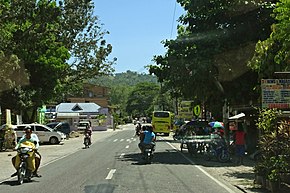
 Santander–Barili–Toledo Road, a component of N830 in Barili | ||||
| Route information | ||||
| Maintained by Department of Public Works and Highways (DPWH) | ||||
| Length | 95 km (59 mi) | |||
| Major junctions | ||||
| South end | ||||
| North end | ||||
| Location | ||||
| Country | Philippines | |||
| Provinces | Cebu | |||
| Towns | Samboan, Ginatilan, Malabuyoc, Alegria, Badian, Moalboal, Alcantara, Ronda, Dumanjug, Barili | |||
| Highway system | ||||
| ||||
| ||||
National Route 830 (N830) is a secondary route that forms part of the Philippine highway network from Samboan to Barili in Cebu, Philippines. There are four components of the route, namely Natalio Bacalso Avenue (in Samboan), Santander–Barili–Toledo Road, Carcar–Barili Road and Carcar–Barili–Mantalongon Road.[1][2][3]
Route description
[edit]The route starts as Natalio Bacalso Avenue (Cebu South Road) from a route change from National Route 8 (N8) at the Santander–Samboan boundary. Shortly, the road is changed to Santander–Barili–Toledo Road. It then traverses the western coastal municipalities of Ginatilan, Malabuyoc, Alegria, Badian, Moalboal, Alcantara, Ronda, Dumanjug, and Barili.
In Barili, it veers to the east away from Cebu's western coast towards the city proper, where it transitions as Carcar–Barili Road at its intersection with Felix Paras Street in poblacion. The route then meets its northern end at the intersection with Toledo–Pinamungahan–Alonguinsan–Mantalongon Road in Barangay Mantalongon.[4]
History
[edit]The predecessors of N830 are Highway 301 from Samboan to Barili and Highway 918 in Barili that existed during the 20th century.[5][6]
During the addition of National Routes by the Department of Public Works and Highways in 2014, the roads Natalio Bacalso Avenue (in Santander), Santander—Barili–Toledo Road, Carcar–Barili Road and Carcar–Barili–Mantapuyan Road were designated components of N830.
References
[edit]- ^ "Cebu 2nd". Department of Public Works and Highways. Retrieved August 30, 2021.
- ^ "Cebu 3rd". Department of Public Works and Highways. Retrieved August 30, 2021.
- ^ "Cebu 4th". Department of Public Works and Highways. Retrieved August 30, 2021.
- ^ "Road and Bridge Inventory". Department of Public Works and Highways. Retrieved June 29, 2023.
- ^ NC 51-7 Cebu City (Map). 1:250,000. Washington D.C.: Army Map Service, Corps of Engineers. 1954. Retrieved June 29, 2023.
- ^ NC 51-10 Dumaguete City (Map). 1:250,000. Washington D.C.: Army Map Service, Corps of Engineers. 1954. Retrieved June 29, 2023.

