Mweya Airport
Mweya Airport | |||||||||||
|---|---|---|---|---|---|---|---|---|---|---|---|
| Summary | |||||||||||
| Airport type | Civilian | ||||||||||
| Owner | Queen Elizabeth National Park | ||||||||||
| Serves | Mweya, Uganda | ||||||||||
| Location | Mweya, Uganda | ||||||||||
| Elevation AMSL | 3,200 ft / 980 m | ||||||||||
| Coordinates | 00°11′39″S 029°53′38″E / 0.19417°S 29.89389°E | ||||||||||
 | |||||||||||
| Runways | |||||||||||
| |||||||||||
Source: Google Maps[1] | |||||||||||
Mweya Airport (ICAO: HUMW) is a small civilian airport in Uganda. It is one of the 46 airports in the country.[2]
Location
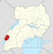
[edit]Mweya Airport is located in Mweya, Kasese District, in western Uganda, approximately 283 kilometres (176 mi), by air, west of Entebbe International Airport, the country's largest civilian and military airport.[3]
Overview
[edit]Mweya Airport serves the area of Mweya and the neighboring areas of Queen Elizabeth National Park and the Lake Katwe Explosion Crater.[4][5] As of January 2010, the airport was not under the administration of the Uganda Civil Aviation Authority.[6] Mweya Airport receives daily flights from Murchison Falls National Park, Entebbe International Airport and Kajjansi Airfield, which are frequently used by tourists to visit Queen Elizabeth National Park.[7]
Airlines and destinations
[edit]| Airlines | Destinations |
|---|---|
| Aerolink Uganda | Entebbe[8] |
External links
[edit]See also
[edit]References
[edit]- ^ Google Maps - Mweya
- ^ "Uganda". CIA World Factbook.
Airports: 46 (2010)
- ^ Nautical Distance Between Entebbe and Mweya with Map
- ^ "Lake Kwatwe Uganda Safaris". Queen Elizabeth National Park Uganda. 2012-09-28. Retrieved 2018-08-29.
- ^ "Google Maps". Google Maps. Retrieved 2018-08-29.
- ^ Mweya Airport Not Under Uganda CAA Administration Archived 2010-02-16 at archive.today
- ^ "Flight Schedule to Queen Elizabeth National Park". Savannah Wings. Retrieved 2022-06-01.
- ^ Aerolink Uganda (2019). "Aerolink Uganda Destinations". Entebbe: Aerolink Uganda. Retrieved 17 July 2019.

