Mount Church (Alaska)
Appearance
| Mount Church | |
|---|---|
 North aspect | |
| Highest point | |
| Elevation | 7,621 ft (2,323 m)[1] |
| Prominence | 3,920 ft (1,190 m)[2] |
| Coordinates | 62°52′45″N 150°41′00″W / 62.87917°N 150.68333°W[3] |
| Geography | |
 | |
| Interactive map of Mount Church | |
| Location | Matanuska-Susitna Borough Alaska, United States |
| Parent range | Alaska Range |
| Topo map | USGS Talkeetna D-2 |
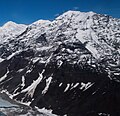
Mount Church is a 7,621-foot (2,323 m) mountain in the Alaska Range, in Denali National Park and Preserve, overlooking Ruth Glacier.[3][2] It is situated on the west side of the Ruth Gorge and 0.87 mi (1 km) southeast of Mount Grosvenor, which is the nearest higher neighbor.[1] The mountain was named by famed explorer Dr. Frederick Cook who claimed the first ascent of Mount McKinley in 1906, but was later disproved.[4]
Climate
[edit]Based on the Köppen climate classification, Mount Church is located in a subarctic climate zone with long, cold, snowy winters, and cool summers.[5] Winter temperatures can drop below −20 °C with wind chill factors below −30 °C. The months May through June offer the most favorable weather for climbing or viewing.
Gallery
[edit]See also
[edit]References
[edit]- ^ a b "Mount Church". Peakbagger.com. Retrieved 2013-04-11.
- ^ a b "Mount Church". Bivouac.com. Retrieved 2013-04-11.
- ^ a b "Mount Church". Geographic Names Information System. United States Geological Survey, United States Department of the Interior. Retrieved 2013-04-11.
- ^ Americanalpineclub.org Four Ascents in the Great Gorge of the Ruth Glacier
- ^ Peel, M. C.; Finlayson, B. L.; McMahon, T. A. (2007). "Updated world map of the Köppen−Geiger climate classification". Hydrol. Earth Syst. Sci. 11: 1633–1644. ISSN 1027-5606.
External links
[edit]- Weather forecast: Mount Church


