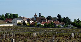
Morey-Saint-Denis
Appearance
Morey-Saint-Denis | |
|---|---|
 A general view of Morey-Saint-Denis | |
| Coordinates: 47°11′47″N 4°57′51″E / 47.1964°N 4.9642°E | |
| Country | France |
| Region | Bourgogne-Franche-Comté |
| Department | Côte-d'Or |
| Arrondissement | Beaune |
| Canton | Longvic |
| Intercommunality | Gevrey-Chambertin et Nuits-Saint-Georges |
| Government | |
| • Mayor (2020–2026) | Jean-Luc Rosier[1] |
Area 1 | 7.83 km2 (3.02 sq mi) |
| Population (2021)[2] | 645 |
| • Density | 82/km2 (210/sq mi) |
| Time zone | UTC+01:00 (CET) |
| • Summer (DST) | UTC+02:00 (CEST) |
| INSEE/Postal code | 21442 /21220 |
| Elevation | 222–472 m (728–1,549 ft) |
| 1 French Land Register data, which excludes lakes, ponds, glaciers > 1 km2 (0.386 sq mi or 247 acres) and river estuaries. | |
Morey-Saint-Denis (French pronunciation: [mɔʁɛ sɛ̃ dəni]) is a commune in the Côte-d'Or department in eastern France.
Population
[edit]| Year | Pop. | ±% |
|---|---|---|
| 1962 | 664 | — |
| 1968 | 740 | +11.4% |
| 1975 | 718 | −3.0% |
| 1982 | 653 | −9.1% |
| 1990 | 639 | −2.1% |
| 1999 | 673 | +5.3% |
| 2008 | 687 | +2.1% |
Wine
[edit]Morey-Saint-Denis is situated in the Northern section of the Côte d'Or called Côte de Nuits. It is one of the principal wine producing villages of the region.
Within Morey-Saint-Denis there are five Grand Cru appellations and 20 Premier Cru vineyards. The Bonnes Mares appellation straddles the border between Morey-Saint-Denis and Chambolle-Musigny and therefore can be produced in either commune [1].
Grand Cru appellations
[edit]Premier Cru vineyards
[edit]- Les Genevrières
- Monts Luisants
- Les Chaffots
- Clos Baulet
- Les Blanchards
- Les Gruenchers
- La Riotte
- Les Millandes
- Les Faconnières
- Les Charrières
- Clos des Ormes
- Aux Charmes
- Aux Cheseaux
- Les Chenevery
- Le Village
- Les Sorbés
- Clos Sorbé
- La Bussière
- Les Ruchots
See also
[edit]References
[edit]- ^ "Répertoire national des élus: les maires". data.gouv.fr, Plateforme ouverte des données publiques françaises (in French). 9 August 2021.
- ^ "Populations légales 2021" (in French). The National Institute of Statistics and Economic Studies. 28 December 2023.
Wikimedia Commons has media related to Morey-Saint-Denis.


