Moravany (Brno-Country District)
Moravany | |
|---|---|
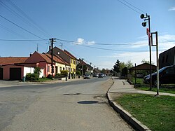
 Main road of Moravany | |
| Coordinates: 49°8′44″N 16°34′34″E / 49.14556°N 16.57611°E | |
| Country | |
| Region | South Moravian |
| District | Brno-Country |
| First mentioned | 1289 |
| Area | |
| • Total | 6.64 km2 (2.56 sq mi) |
| Elevation | 246 m (807 ft) |
| Population (2024-01-01)[1] | |
| • Total | 3,497 |
| • Density | 530/km2 (1,400/sq mi) |
| Time zone | UTC+1 (CET) |
| • Summer (DST) | UTC+2 (CEST) |
| Postal code | 664 48 |
| Website | www |
Moravany (German: Morbes) is a municipality and village in Brno-Country District in the South Moravian Region of the Czech Republic. It has about 3,500 inhabitants.
Geography
[edit]Moravany is located south of Brno, in its immediate vicinity. It lies on the border between the Dyje–Svratka Valley and Bobrava Highlands. The highest point is at 338 m (1,109 ft) above sea level. The Bobrava River flows along the southeastern municipal border.
History
[edit]The first written mention of Moravany is from 1289. The village was owned by the Cistercian monastery in Staré Brno until its abolishment in 1782, then the owners often changed.[2]
Demographics
[edit]The population of Moravany has almost tripled since 2001.
|
|
| ||||||||||||||||||||||||||||||||||||||||||||||||||||||
| Source: Censuses[3][4] | ||||||||||||||||||||||||||||||||||||||||||||||||||||||||
Transport
[edit]The D1 motorway from Prague to Brno passes through the territory of Moravany.
Sights
[edit]The main landmark of Moravany is the Church of Saint Wenceslaus. It has an early Gothic core from the first half of the 13th century. It was rebuilt into its current Baroque form in the mid-18th century.[5]
References
[edit]- ^ "Population of Municipalities – 1 January 2024". Czech Statistical Office. 2024-05-17.
- ^ "Historie" (in Czech). Obec Moravany. Retrieved 2023-11-20.
- ^ "Historický lexikon obcí České republiky 1869–2011" (in Czech). Czech Statistical Office. 2015-12-21.
- ^ "Population Census 2021: Population by sex". Public Database. Czech Statistical Office. 2021-03-27.
- ^ "Kostel sv. Václava" (in Czech). National Heritage Institute. Retrieved 2023-11-20.


