Montgomery County Airpark
Montgomery County Airpark | |||||||||||
|---|---|---|---|---|---|---|---|---|---|---|---|
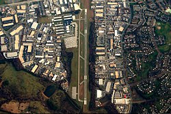
 The Montgomery County Airpark in 2006 | |||||||||||
| Summary | |||||||||||
| Airport type | Public | ||||||||||
| Owner | Montgomery County Revenue Authority | ||||||||||
| Location | Gaithersburg, Maryland, U.S. | ||||||||||
| Elevation AMSL | 539 ft / 164.3 m | ||||||||||
| Coordinates | 39°10′06″N 77°09′57.6″W / 39.16833°N 77.166000°W | ||||||||||
| Map | |||||||||||
 | |||||||||||
| Runways | |||||||||||
| |||||||||||
Montgomery County Airpark (IATA: GAI, ICAO: KGAI, FAA LID: GAI) is a U.S. public airport located three miles (5 km) northeast of the city of Gaithersburg, in Montgomery County, Maryland, United States.
History
[edit]1960s
[edit]The airport was built by Silver Spring developer William E. Richardson in 1960, in an area that was then rural.[1][2] The original plan was to build an airport, a 9-hole golf course, and a hotel on the 388 acres (1.6 km2) of land.[3][4] The Montgomery County Planning Board voted 3–2 in favor of rezoning the land to allow the airport to be built.[4] Those in favor on the Board said that Montgomery County "desperately" needed an airport and that the additional industry would help bring in tax revenue, while those opposed said that the airport would destroy the rural aspect of the surrounding area.[4]
Richardson deeded title to the land to Montgomery County, which leased the land back to him to operate the airport.[1] Richardson planned to operate charter flights and an air taxi to National Airport, Baltimore's Friendship Airport, and the soon-to-be-opened Dulles Airport.[1] The airport was dedicated on October 22, 1960.[5] The airport was initially managed by Richardson's son, James E. Richardson, and Richard T. Kreuzburg, a former Capital Airlines pilot.[5]
After having a simple hangar during its first four years of operation, a terminal building was built in 1964.[6]
2000s
[edit]On July 20, 2001, one of the hijackers in the future September 11 attacks, Hani Hanjour, flew to the Montgomery County Airpark from Fairfield, New Jersey, on a practice flight with fellow hijacker Nawaf Alhazmi.[7][8]
Facilities
[edit]Runways
[edit]Montgomery County Airpark covers 125 acres (51 ha) and has one runway.
- Runway 14/32: 4,202 x 75 ft. (1,281 x 23 m), surface: asphalt (32 - right traffic)
Navigational aids
[edit]- WAAS/GPS/RNAV MDA 262 agl
- VOR 155 degree from FDK 109.0 MDA 600 agl
On-field services
[edit]- DC Metro Aviation Services
- Full-service FBO - 100LL JetA
- Hangar-tiedown rental
- Charter operators
- Open Air Charters - Part 135
- Flight schools
- Bravo Flight Training
- Positive Attitude Aviation
- Pilot in Training Flight Academy
- Washington International Flight Academy (WIFA)
- Civil Air Patrol
- Food & beverage
- Cafe Sophie
Flying clubs
[edit]- Congressional Flying Club[9]
- Octopus Flying Club
- Inn Flying Club
- TSS Flying Club[10]
- TSS Flying Club was formed in 1957 and remains one of the largest flying clubs in the Washington-Baltimore region today. TSS has 65 members and five well equipped aircraft including two Cessna 172 180hp, Cessna 182S, Cessna 182RG, and a Vans RV12 certified light sport aircraft with glass cockpit.
Accidents and incidents
[edit]At least 30 plane crashes have occurred at or near Montgomery County Airpark since 1983. [11]
On December 8, 2014, a plane crashed into houses while on approach to Runway 14 at Montgomery County Airpark. Six people died, the three occupants of the plane and three people in the house the plane hit.[12]
On November 27, 2022, a Mooney M20J-201 (N201RF) crashed into a powerline while on approach to Runway 14 at Montgomery County Airpark. Both occupants survived with some injuries but were trapped in the aircraft for several hours.[11]
See also
[edit]References
[edit]- ^ a b c "New Private Airport Scans the Sky, Optimistic About Boom in Flying". The Washington Post. July 25, 1960. p. 25. ProQuest 141208605.
- ^ Davenport, Dorrie (July 1, 1959). "Rezoning of 388 Acres for Airport Is Sought in County]". The Washington Post. p. A24. ProQuest 149211909
- ^ "Airport Site To Include Golf, Hotel". The Washington Post. August 25, 1959. p. B8. ProQuest 149246752
- ^ a b c "Plans Unit Votes, 3 to 2, For Airport". The Washington Post. September 3, 1959. p. C23. ProQuest 141019906
- ^ a b "$750,000 Airport Dedicated Northeast of Gaithersburg". The Washington Post. October 23, 1960. p. D21. ProQuest 141157629.
- ^ "250 Attend Montgomery Airpark Fete". The Washington Post. September 24, 1964. p. E18. ProQuest 142147783.
- ^ "Complete 911 Timeline: Hani Hanjour". History Commons. Archived from the original on 2017-08-30.
{{cite web}}: CS1 maint: bot: original URL status unknown (link) - ^ Final Report of the National Commission on Terrorist Attacks Upon the United States (PDF). 2004. p. 242. Retrieved October 1, 2017.
- ^ "Congressional Flying Club". flyingclub.info.
- ^ "TSS Flying Club - Fun, Affordable Flying Club in the Washington DC Area". www.tssflyingclub.org.
- ^ a b Lazo, Luz; Aratani, Lori; Duncan, Ian (2022-11-28). "Federal probe underway in crash of plane that hit Maryland power lines". The Washington Post. Retrieved 2022-11-30.
- ^ Morse, Dan; Halsey III, Ashley (2014-12-08). "Six killed when plane crashes into house in Gaithersburg". The Washington Post. Retrieved 2022-11-30.
Further reading
[edit]- Airport Master Record (FAA Form 5010), also available as a printable form (PDF)
External links
[edit]- Official website
- Montgomery County Revenue Authority
- Resources for this airport:
- FAA airport information for GAI
- AirNav airport information for KGAI
- ASN accident history for GAI
- FlightAware airport information and live flight tracker
- NOAA/NWS weather observations: current, past three days
- SkyVector aeronautical chart, Terminal Procedures
- Airports in Maryland
- Transportation buildings and structures in Montgomery County, Maryland
- Buildings and structures in Gaithersburg, Maryland
- Airports established in 1960
- 1960 establishments in Maryland
- Southern United States airport stubs
- Maryland building and structure stubs
- Maryland transportation stubs


