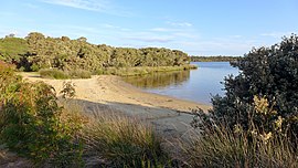
Molloy Island, Western Australia
Appearance
| Molloy Island Western Australia | |
|---|---|
 Sandy Beach, Molloy Island, in 2015 | |
 | |
| Coordinates | 34°15′54″S 115°12′44″E / 34.26500°S 115.21222°E |
| Population | 163 (SAL 2021)[1] |
| Postcode(s) | 6290 |
| Area | 2.9 km2 (1.1 sq mi) |
| LGA(s) | Shire of Augusta-Margaret River |
| State electorate(s) | Warren-Blackwood |
| Federal division(s) | Forrest |
Molloy Island is a small townsite located in the South West region of Western Australia in the Shire of Augusta-Margaret River, specifically on the island in the Blackwood River.[2]
The island was the location of an attempt at possum farming in the 1920s.[3][4][5]
References
[edit]- ^ Australian Bureau of Statistics (28 June 2022). "Molloy Island (suburb and locality)". Australian Census 2021 QuickStats. Retrieved 28 June 2022.
- ^ Wylie, Norman; HRRC (1962), Blackwood River from Molloy Island, Augusta, 8.3.62, retrieved 1 January 2023
- ^ "Basic Wage in New South Wales". Daily Commercial News And Shipping List. No. 10, 562. New South Wales, Australia. 27 April 1922. p. 9 (Weekly Summary.). Retrieved 1 January 2023 – via National Library of Australia.
- ^ "54 Years As Printer and Pressman". The Farmers' Weekly. Vol. 7, no. 334. Western Australia. 31 December 1953. p. 8. Retrieved 1 January 2023 – via National Library of Australia.
- ^ "News and Notes". The South-western News. Vol. XIX, no. 938. Western Australia. 24 March 1922. p. 2. Retrieved 1 January 2023 – via National Library of Australia.
External links
[edit]![]() Media related to Molloy Island at Wikimedia Commons
Media related to Molloy Island at Wikimedia Commons

