Module:Location map/data/Northern and Central Europe/doc
Appearance
Usage
| name | Northern and Central Europe | ||
|---|---|---|---|
| x | ((131.579*( cos( $1*pi/180 )*sin( ($2-10)*pi/180 ) ) * ( ((1 + sin( $1*pi/180 )*sin( 52*pi/180 ) + cos( $1*pi/180 )*cos( 52*pi/180 )*cos( ($2-10)*pi/180 ) ) *0.5)^ -0.5) - (-36.388))*14.0134-200)/6 | ||
| y | ((55.11 - 153.610*( cos( 52* pi/180)*sin( $1*pi/180 ) - sin( 52*pi/180 )*cos( $1*pi/180 )*cos( ($2-10)*pi/180 ) ) * ( ((1 + sin( $1*pi/180 )*sin( 52*pi/180 ) + cos( $1*pi/180 )*cos( 52*pi/180 )*cos( ($2-10)*pi/180 ) ) *0.5)^ -0.5))*11.9834-174.92)/7.5 | ||
| image | Northern and Central Europe location map.svg
| ||

| |||
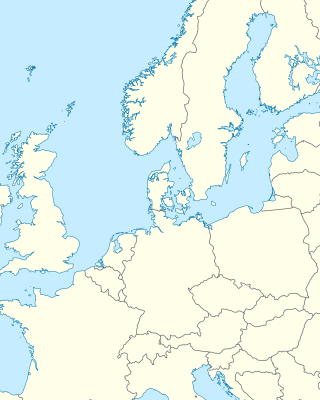
Module:Location map/data/Northern and Central Europe is a location map definition used to overlay markers and labels on an Lambert azimuthal equal-area projection map of Northern and Central Europe. The markers are placed by latitude and longitude coordinates on the default map or a similar map image.
Usage
These definitions are used by the following templates when invoked with parameter "Northern and Central Europe":
{{Location map|Northern and Central Europe |...}}{{Location map many|Northern and Central Europe |...}}{{Location map+|Northern and Central Europe |...}}{{Location map~|Northern and Central Europe |...}}
Map definition
name = Northern and Central Europe- Name used in the default map caption
image = Northern and Central Europe location map.svg- The default map image, without "Image:" or "File:"
x = ((131.579*( cos( $1*pi/180 )*sin( ($2-10)*pi/180 ) ) * ( ((1 + sin( $1*pi/180 )*sin( 52*pi/180 ) + cos( $1*pi/180 )*cos( 52*pi/180 )*cos( ($2-10)*pi/180 ) ) *0.5)^ -0.5) - (-36.388))*14.0134-200)/6- An expression to calculate a location on the map via its longitude; evaluates as 0 along the left edge and 100 along the right edge
y = ((55.11 - 153.610*( cos( 52* pi/180)*sin( $1*pi/180 ) - sin( 52*pi/180 )*cos( $1*pi/180 )*cos( ($2-10)*pi/180 ) ) * ( ((1 + sin( $1*pi/180 )*sin( 52*pi/180 ) + cos( $1*pi/180 )*cos( 52*pi/180 )*cos( ($2-10)*pi/180 ) ) *0.5)^ -0.5))*11.9834-174.92)/7.5- An expression to calculate a location on the map via its latitude; evaluates as 0 along the top edge and 100 along the bottom edge
Examples using location map templates
Location map
{{Location map | Northern and Central Europe
| width   = 250
| label   = Hamburg
| lat_deg = 53.57
| lon_deg = 10.00
}}
Location map many
Two locations in Europe
{{Location map many | Northern and Central Europe
| width    = 250
| caption  = Two locations in Europe
| label1   = Trondheim
| lat1_deg = 63.43
| lon1_deg = 10.39
| label2   = Venice
| lat2_deg = 45.44
| lon2_deg = 12.34
}}
Location map+
Two locations in Europe
{{Location map+ | Northern and Central Europe
| caption  = Two locations in Europe
| width   = 250
| places  =
  {{Location map~ | Northern and Central Europe
  | label   = Bordeaux
  | lat_deg = 44.84
  | lon_deg = -0.58
  }}
  {{Location map~ | Northern and Central Europe
  | label   = Rīga
  | lat_deg = 56.95
  | lon_deg = 24.11
  }}
}}
See also
Location map templates
- Template:Location map, to display one mark and label using latitude and longitude
- Template:Location map many, to display up to nine marks and labels
- Template:Location map+, to display an unlimited number of marks and labels

