Mirachowo
Appearance
Mirachowo | |
|---|---|
Village | |
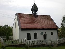
 Chapel in Mirachowo (bd. 1740) | |
| Coordinates: 54°23′42″N 18°1′40″E / 54.39500°N 18.02778°E | |
| Country | |
| Voivodeship | Pomeranian |
| County | Kartuzy |
| Gmina | Kartuzy |
| Population | 913 |
Mirachowo [miraˈxɔvɔ] (Kashubian: Mirchòwò)[1] is a village in the administrative district of Gmina Kartuzy, within Kartuzy County, Pomeranian Voivodeship, in northern Poland.[2] It lies approximately 14 kilometres (9 mi) north-west of Kartuzy and 40 km (25 mi) west of the regional capital Gdańsk.
For details of the history of the region, see History of Pomerania.
References
[edit]- ^ "Lista gmin wpisanych na podstawie art. 12 ustawy z dnia 6 stycznia 2005 r. o mniejszościach narodowych i etnicznych oraz o języku regionalnym (Dz. U. z 2015 r. poz. 573) do Rejestru gmin, na których obszarze używane są nazwy w języku mniejszości" (PDF). mswia.gov.pl. Archived from the original (PDF) on 2016-03-04. Retrieved 2016-04-26.
- ^ "Central Statistical Office (GUS) - TERYT (National Register of Territorial Land Apportionment Journal)" (in Polish). 2008-06-01.


