Milford Branch
| Milford Branch | |||||||||||||||||||||||||||||||||||||||||||||||||||||||||||||||||||||||||||||||||||||||||||||||||||||||||||||||||||||||||||||||||||||||||||||||||||||||||
|---|---|---|---|---|---|---|---|---|---|---|---|---|---|---|---|---|---|---|---|---|---|---|---|---|---|---|---|---|---|---|---|---|---|---|---|---|---|---|---|---|---|---|---|---|---|---|---|---|---|---|---|---|---|---|---|---|---|---|---|---|---|---|---|---|---|---|---|---|---|---|---|---|---|---|---|---|---|---|---|---|---|---|---|---|---|---|---|---|---|---|---|---|---|---|---|---|---|---|---|---|---|---|---|---|---|---|---|---|---|---|---|---|---|---|---|---|---|---|---|---|---|---|---|---|---|---|---|---|---|---|---|---|---|---|---|---|---|---|---|---|---|---|---|---|---|---|---|---|---|---|---|---|---|
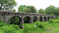
 Holliston viaduct along the Milford Branch | |||||||||||||||||||||||||||||||||||||||||||||||||||||||||||||||||||||||||||||||||||||||||||||||||||||||||||||||||||||||||||||||||||||||||||||||||||||||||
| Overview | |||||||||||||||||||||||||||||||||||||||||||||||||||||||||||||||||||||||||||||||||||||||||||||||||||||||||||||||||||||||||||||||||||||||||||||||||||||||||
| Status | Abandoned | ||||||||||||||||||||||||||||||||||||||||||||||||||||||||||||||||||||||||||||||||||||||||||||||||||||||||||||||||||||||||||||||||||||||||||||||||||||||||
| Owner | CSX (North of Whitney Street in Sherborn) Upper Charles Rail Trail (South of Whitney Street in Sherborn) | ||||||||||||||||||||||||||||||||||||||||||||||||||||||||||||||||||||||||||||||||||||||||||||||||||||||||||||||||||||||||||||||||||||||||||||||||||||||||
| Locale | MetroWest Towns of Framingham, Sherborn, Holliston, and Milford | ||||||||||||||||||||||||||||||||||||||||||||||||||||||||||||||||||||||||||||||||||||||||||||||||||||||||||||||||||||||||||||||||||||||||||||||||||||||||
| Termini | |||||||||||||||||||||||||||||||||||||||||||||||||||||||||||||||||||||||||||||||||||||||||||||||||||||||||||||||||||||||||||||||||||||||||||||||||||||||||
| Continues from | Boston and Worcester Railroad, now the Framingham/Worcester Line | ||||||||||||||||||||||||||||||||||||||||||||||||||||||||||||||||||||||||||||||||||||||||||||||||||||||||||||||||||||||||||||||||||||||||||||||||||||||||
| Stations | 8 | ||||||||||||||||||||||||||||||||||||||||||||||||||||||||||||||||||||||||||||||||||||||||||||||||||||||||||||||||||||||||||||||||||||||||||||||||||||||||
| Service | |||||||||||||||||||||||||||||||||||||||||||||||||||||||||||||||||||||||||||||||||||||||||||||||||||||||||||||||||||||||||||||||||||||||||||||||||||||||||
| Type | Railroad | ||||||||||||||||||||||||||||||||||||||||||||||||||||||||||||||||||||||||||||||||||||||||||||||||||||||||||||||||||||||||||||||||||||||||||||||||||||||||
| System | Boston and Albany Railroad | ||||||||||||||||||||||||||||||||||||||||||||||||||||||||||||||||||||||||||||||||||||||||||||||||||||||||||||||||||||||||||||||||||||||||||||||||||||||||
| History | |||||||||||||||||||||||||||||||||||||||||||||||||||||||||||||||||||||||||||||||||||||||||||||||||||||||||||||||||||||||||||||||||||||||||||||||||||||||||
| Commenced | 1847 | ||||||||||||||||||||||||||||||||||||||||||||||||||||||||||||||||||||||||||||||||||||||||||||||||||||||||||||||||||||||||||||||||||||||||||||||||||||||||
| Opened | September 1847 | ||||||||||||||||||||||||||||||||||||||||||||||||||||||||||||||||||||||||||||||||||||||||||||||||||||||||||||||||||||||||||||||||||||||||||||||||||||||||
| Completed | July 1848 | ||||||||||||||||||||||||||||||||||||||||||||||||||||||||||||||||||||||||||||||||||||||||||||||||||||||||||||||||||||||||||||||||||||||||||||||||||||||||
| Closed | 1980 | ||||||||||||||||||||||||||||||||||||||||||||||||||||||||||||||||||||||||||||||||||||||||||||||||||||||||||||||||||||||||||||||||||||||||||||||||||||||||
| Technical | |||||||||||||||||||||||||||||||||||||||||||||||||||||||||||||||||||||||||||||||||||||||||||||||||||||||||||||||||||||||||||||||||||||||||||||||||||||||||
| Line length | 11.97 miles (19.26 km) | ||||||||||||||||||||||||||||||||||||||||||||||||||||||||||||||||||||||||||||||||||||||||||||||||||||||||||||||||||||||||||||||||||||||||||||||||||||||||
| Character | heavy rail, abandoned | ||||||||||||||||||||||||||||||||||||||||||||||||||||||||||||||||||||||||||||||||||||||||||||||||||||||||||||||||||||||||||||||||||||||||||||||||||||||||
| Track gauge | 4 ft 8+1⁄2 in (1,435 mm) | ||||||||||||||||||||||||||||||||||||||||||||||||||||||||||||||||||||||||||||||||||||||||||||||||||||||||||||||||||||||||||||||||||||||||||||||||||||||||
| Electrification | None | ||||||||||||||||||||||||||||||||||||||||||||||||||||||||||||||||||||||||||||||||||||||||||||||||||||||||||||||||||||||||||||||||||||||||||||||||||||||||
| |||||||||||||||||||||||||||||||||||||||||||||||||||||||||||||||||||||||||||||||||||||||||||||||||||||||||||||||||||||||||||||||||||||||||||||||||||||||||
The Milford Branch is an abandoned railroad line in Massachusetts. The line formerly ran from Milford to Framingham, traveling through Holliston and Sherborn, connecting to the Boston Subdivision in Framingham and the Milford Secondary in Milford. The line was originally part of the Boston and Albany Railroad, and the end of the line was later abandoned under Penn Central, before the rest of the line was abandoned by Conrail.[1] Although the line passes through Sherborn and terminates in Framingham, the majority of the line lies in Holliston.
History
[edit]The Boston and Worcester Railroad began construction of the Milford Branch in early 1847, heading south from their mainline at Framingham, and opened from Framingham to Holliston by September 1847.[2] and by July 1848 had reached its southern terminus in Milford.[3][4] Originally, the line was proposed to continue south to Woonsocket, Rhode Island, but this would have interfered with the Norfolk County Railroad, so it was decided to terminate the line in Milford.[4]
In Milford, the line interchanged with what was then known as the Hopkinton and Milford Railroad, later the Milford and Woonsocket Railroad, and today's CSX Milford Secondary.[5] This line was built in stages between 1869 and 1872.[2] In 1893, the Natick Street Railway expanded south through Sherborn to Ashland, but the Milford Branch remained the largest railroad in Milford.
The line continued thriving throughout the early 20th century, but by the 1950s, as with many railroads across the country, the line began struggling. By 1958, the line had only one train per day in each direction, running as a shuttle to/from Framingham during the rush hour only and serving Holliston and Milford stations only.[6][7] Passenger service could not last much longer, and the Milford Branch's very last passenger train arrived into Milford on the evening of March 28, 1959, after 111 years of service.[8]
Freight service still continued under the B&A, but the line was by this point an unimportant branchline. Eventually, as with the rest of the former B&A, the Milford Branch came under the control of Penn Central in their 1968 creation. The line continued having minimal freight service throughout the 1960s and 70s, but in the early 1980s, the line -- which was then owned by Conrail -- was abandoned.[9][10] Throughout the 1980s, 90s, and into the 2000s, the line sat abandoned, with tracks at least partially intact until 2004.[11][12][13]
Starting in 2017, portions of the rail line began being converted into the Upper Charles Rail Trail, which as of 2024 has been completed from Whitney Street in Sherborn south to Downtown Milford.[14][15][16]
Remnants
[edit]The following remnants still exist along the line:
- The right-of-way from Sherborn to Milford is preserved as the Upper Charles Rail Trail.[15]
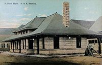
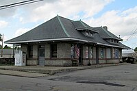
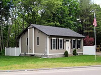
- The East Holliston, Holliston, and Milford station buildings are still standing.[11][17]
- The 8-Arch Bridge, also known as the Holliston Viaduct or the Woolen Mill Bridge, still stands slightly north of Holliston.[18]
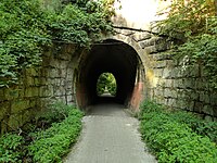
- The Phipps Tunnel still remains just south of Holliston.[19]
Modern transit
[edit]The MetroWest Regional Transit Authority route 6 roughly parallels the former path of the line.[20]
Station listing
[edit]| Town | Station | Notes |
|---|---|---|
| Framingham | Framingham[21] | still active as an MBTA and Amtrak station |
| Sherborn | Whitney[21] | |
| Holliston | East Holliston[21] | station building still remains[11] |
| Holliston[21] | station building still remains[11] | |
| Metcalf[21] | ||
| Braggville[21] | ||
| Milford | Rocky Hill[21] | |
| Milford[21] | station building still remains[17] |
Gallery
[edit]-
Milford station in 1913
-
The former Holliston station building in 2017
-
The former Milford station building in 2017
-
The former East Holliston station in 2017
-
The Phipps Tunnel in Holliston
-
The Holliston Viaduct in 2017
-
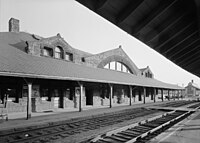
Framingham station in 1959
References
[edit]- ^ "The Milford Branch - Abandoned Rails".
- ^ a b Jacobs, Warren (1928). "Dates of Some of the Principal Events in the History of 100 Years of the Railroad in New England. 1826-1926". The Railway and Locomotive Historical Society Bulletin (17): 15–28. ISSN 0033-8842. JSTOR 43504499.
- ^ "Town of Milford History | Milford MA". www.milfordma.gov. Retrieved 2024-05-12.
- ^ a b Ballou, Adin (1882). History of the Town of Milford, Worcester County Massachusetts: From Its First Settlement to 1881. Yale University Press. pp. 337–338. ISBN 978-1332310968.
- ^ https://ngmdb.usgs.gov/img4/ht_icons/overlay/MA/MA_Blackstone_352487_1889_62500_geo.jpg [bare URL image file]
- ^ https://www.canadasouthern.com/caso/ett/images/ba-tt-0457.pdf, p. 14 on PDF
- ^ Railroad, Boston and Albany (1958-04-27), English: April 1958 timetable of Boston–Worcester suburban service plus Milford Branch service, retrieved 2024-05-12
- ^ "Last run of Boston-Albany Railroad, Milford stop". www.digitalcommonwealth.org. Retrieved 2024-05-12.
- ^ "Milford Station [B&A] - Milford, MA | Railroad History". www.nashuacitystation.org. Retrieved 2024-05-12.
- ^ https://ngmdb.usgs.gov/img4/ht_icons/overlay/MA/MA_Holliston_351021_1969_25000_geo.jpg [bare URL image file]
- ^ a b c d "middlesexco". www.lightlink.com. Retrieved 2024-05-12.
- ^ "Abandoned Framingham Autorack Facility?". Trainorders.com Discussion. Retrieved 2024-05-12.
- ^ https://www.lightlink.com/sglap3/massachusetts/easthollistonNA.jpg [bare URL image file]
- ^ https://ngmdb.usgs.gov/img4/ht_icons/overlay/MA/MA_Boston_353155_1985_100000_geo.jpg [bare URL image file]
- ^ a b "Home". Upper Charles Trail. 2013-03-06. Retrieved 2024-05-12.
- ^ "Sherborn to reiki spa". Sherborn to reiki spa. Retrieved 2024-05-12.
- ^ a b "worcesterco". www.lightlink.com. Retrieved 2024-05-12.
- ^ "Google Maps". Google Maps. Retrieved 2024-05-12.
- ^ "Google Maps". Google Maps. Retrieved 2024-05-12.
- ^ "Route 6 (M-F) :: MWRTA". www.mwrta.com. Retrieved 2024-05-12.
- ^ a b c d e f g h https://www.canadasouthern.com/caso/images/passenger-station-list-1954.pdf, p. 18
External links
[edit]![]() Media related to Milford Branch at Wikimedia Commons
Media related to Milford Branch at Wikimedia Commons

