Milaor
Milaor | |
|---|---|
| Municipality of Milaor | |
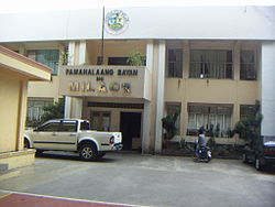
 Municipal Hall | |
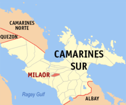
 Map of Camarines Sur with Milaor highlighted | |
Location within the Philippines | |
| Coordinates: 13°35′44″N 123°10′41″E / 13.5956°N 123.1781°E | |
| Country | Philippines |
| Region | Bicol Region |
| Province | Camarines Sur |
| District | 2nd district |
| Founded | May 1, 1585 |
| Barangays | 20 (see Barangays) |
| Government | |
| • Type | Sangguniang Bayan |
| • Mayor | Anthony R. Reyes |
| • Vice Mayor | Leodel P. Menes |
| • Representative | Luis Raymund F. Villafuerte Jr. |
| • Municipal Council | Members |
| • Electorate | 23,967 voters (2022) |
| Area | |
| • Total | 33.64 km2 (12.99 sq mi) |
| Elevation | 5.0 m (16.4 ft) |
| Highest elevation | 30 m (100 ft) |
| Lowest elevation | −3 m (−10 ft) |
| Population (2020 census)[3] | |
| • Total | 33,963 |
| • Density | 1,000/km2 (2,600/sq mi) |
| • Households | 7,241 |
| Economy | |
| • Income class | 3rd municipal income class |
| • Poverty incidence | 27.55 |
| • Revenue | ₱ 118 million (2020) |
| • Assets | ₱ 442.6 million (2020) |
| • Expenditure | ₱ 106.6 million (2020) |
| • Liabilities | ₱ 91.98 million (2020) |
| Service provider | |
| • Electricity | Camarines Sur 2 Electric Cooperative (CASURECO 2) |
| Time zone | UTC+8 (PST) |
| ZIP code | 4413 |
| PSGC | |
| IDD : area code | +63 (0)54 |
| Native languages | Central Bikol Tagalog |
| Website | milaor |
Milaor, officially the Municipality of Milaor (Central Bikol: Banwaan kan Milaor; Tagalog: Bayan ng Milaor), is a 3rd class municipality in the province of Camarines Sur, Philippines. According to the 2020 census, it has a population of 33,963 people.[3]
Milaor is part of the Metro Naga Urban Area. It is 17 kilometres (11 mi) from Pili and 433 kilometres (269 mi) from Manila.
History
[edit]The work of evangelization in Milaor began in 1579 when the Franciscan missionaries came to the Philippines upon the order of Pope Sixtus V and King Philip II, and given specific assignment to work in Bicol Region. In 1585, Milaor was declared a parish under the titular patron, Saint Joseph. The first parish administrator was Fray Matias de Andrade, OFM., who arrived in Bikol in 1582 and later became the fifth Bishop of the Diocese of Nueva Caceres.
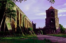
The Franciscans, Fray Juan del Sacramento and Fray Jose dela Virgen, initiated the construction of a church made of bricks and stones. This was built in a place known today as "Sinimbahanan" now a part of Cabusao, where ruins of the concrete foundation may still be found. Frequent attacks from the cimarrones and the tulisanes from nearby Mount Isarog, however, caused the transfer of the church to its present site. Fray Santiago de San Pedro de Alcantara completed the construction in 1730 and added a convent made of wooden materials in 1735. Both the church and the convent were destroyed by fire in 1740 and immediately the reconstruction was undertaken by Fray Francisco delos Santos, OFM. The present belfry was finished in 1840.
Milaor was formerly called "Milaud" or "may-laud". "Laud" means a lowland prone to being flooded, in fact that is being true up to this day. The expression "mapa-laud" means to go to a place which is low or with water, in other words, to go to a "laud". From "Milaud" or "Maylaud" it was transferred to "Milaor". The truth of this matter of the place being always filled with water is corroborated by the fact that in many barangays are to be found shells which thrive on water. These shell fossils mean that in ancient time this place was really covered with water or is frequently flooded to allow these shells or mollusks to thrive in the place.
Originally, Milaor comprised Palestina and the present parishes of Minalabac, San Fernando and Gainza. Until the eve following the uprising Naga City on September 19, 1898, during the Philippine Revolution, the Franciscan considered Milaor as their favorite resting place and abode away from the adjacent rapidly developing settlement that is Naga City today.
Geography
[edit]Barangays
[edit]Milaor is politically subdivided into 20 barangays. Each barangay consists of puroks and some have sitios.
Just like most cities in the Philippines, Milaor has a barangay system which is the core Local Government of the Philippines. Each barangay is headed by a chairman and barangay councils who were elected to office by popular vote of the community registered voters every three years.
- Alimbuyog
- Amparado (Pob)
- Balagbag
- Borongborongan
- Cabugao
- Capucnasan
- Dalipay
- Del Rosario (Pob)
- Flordeliz
- Lipot
- Mayaopayawan
- Maycatmon
- Maydaso
- San Antonio
- San Jose (Pob)
- San Miguel (Pob)
- San Roque (Pob)
- San Vicente (Pob)
- Santo Domingo (Pob)
- Tarusanan
Climate
[edit]| Climate data for Milaor, Camarines Sur | |||||||||||||
|---|---|---|---|---|---|---|---|---|---|---|---|---|---|
| Month | Jan | Feb | Mar | Apr | May | Jun | Jul | Aug | Sep | Oct | Nov | Dec | Year |
| Mean daily maximum °C (°F) | 32 (90) |
32 (90) |
35 (95) |
37 (99) |
37 (99) |
36 (97) |
35 (95) |
33 (91) |
35 (95) |
34 (93) |
33 (91) |
32 (90) |
34 (94) |
| Mean daily minimum °C (°F) | 27 (81) |
27 (81) |
29 (84) |
31 (88) |
32 (90) |
32 (90) |
31 (88) |
29 (84) |
31 (88) |
29 (84) |
28 (82) |
28 (82) |
30 (85) |
| Average precipitation mm (inches) | 37.28 (1.47) |
59.59 (2.35) |
37.03 (1.46) |
75.7 (2.98) |
97.75 (3.85) |
154.2 (6.07) |
285.71 (11.25) |
283.29 (11.15) |
185.08 (7.29) |
371.1 (14.61) |
100.7 (3.96) |
299.0 (11.77) |
1,986.43 (78.21) |
| Average rainy days | 18 | 23 | 16 | 16 | 25 | 28 | 31 | 26 | 27 | 29 | 24 | 29 | 292 |
| Source: World Weather Online (modeled/calculated data, not measured locally)[5] | |||||||||||||
Demographics
[edit]
|
| |||||||||||||||||||||||||||||||||||||||||||||||||||
| Source: Philippine Statistics Authority[6][7][8][9] | ||||||||||||||||||||||||||||||||||||||||||||||||||||
In the 2020 census, the population of Milaor, Camarines Sur, was 33,963 people,[3] with a density of 1,000 inhabitants per square kilometre or 2,600 inhabitants per square mile.
Languages
[edit]Central Bikol language is primarily being used in the town. Most people in Milaor speak the Coastal Bikol (Naga dialect) as their main language. While further south closer to Minalabac speaks a little of Rinconada Bikol which is recognized as a minority language. Tagalog is a secondary language in the town primarily used for tourists and visitors that cannot speak Bicolano language. Residents speak English as well when they go to work or school.
Religion
[edit]Parishes (Catholic Church in Milaor)
[edit]
St. Joseph the Worker Parish
[edit]St. Joseph the Worker is the titular patron saint of the Municipality. The town and parish fiesta are celebrated every 1st day of May. The present parish priest is Rev. Fr. Ruben R. Buena. The vision of the parish is to continue forming Basic Ecclesial Communities, locally called as SKK or Saradit na Kristiyanong Komunidad. The locus and focus of this dream of the Church is by clustering all the neighboring families. Each cluster is composed of 15-20 families.
St. Anthony of Padua Parish
[edit]On May 13, 1994, another parish within the municipality of Milaor was established. The seat is at barangay San Antonio and the titular patron saint is St. Anthony of Padua. At present the parish priest is Rev. Fr. Edgar L. Barias, SOLT.
Economy
[edit]Poverty incidence of Milaor
10
20
30
40
2006
36.90 2009
36.63 2012
27.13 2015
32.81 2018
17.67 2021
27.55 Source: Philippine Statistics Authority[10][11][12][13][14][15][16][17] |
Formerly a sleepy suburb of Naga City Milaor became one of the most commercialized municipalities alongside Sipocot, Calabanga, Pili, Nabua and the nearby town of Canaman. This is due to its proximity to Naga City's CBD II and Almeda CBD. Its location along the National highway also makes it boom. Milaor hosts large Warehouse companies such as CitiHardware, Olivan Depot, Atlantic Bakery, Milaor Trading Corporation, Milaor Cement Corp and others. The municipality has a provincial cockpit arena and several financial institutions such as BDO Network Bank and M Lhuillier.
Most people in the municipality are farmers and fishermen. However, since Milaor is close to Naga City (3 kilometers south), within the Manila-Naga road, and is the site of the upcoming Camarines Sur expressway, it has become a location of a great number of warehouses. Also because of its proximity to Naga City, it has become a population spillover, with many housing subdivisions being located, as well as entertainment centers. Camarines Sur Sports Arena is located in Brgy. Tarusanan.
Typical agricultural produce includes:
- Corn
- Palay (rice)
- Coconut
- Wheat
- Mango
References
[edit]- ^ Municipality of Milaor | (DILG)
- ^ "2015 Census of Population, Report No. 3 – Population, Land Area, and Population Density" (PDF). Philippine Statistics Authority. Quezon City, Philippines. August 2016. ISSN 0117-1453. Archived (PDF) from the original on May 25, 2021. Retrieved July 16, 2021.
- ^ a b c Census of Population (2020). "Region V (Bicol Region)". Total Population by Province, City, Municipality and Barangay. Philippine Statistics Authority. Retrieved 8 July 2021.
- ^ "PSA Releases the 2021 City and Municipal Level Poverty Estimates". Philippine Statistics Authority. 2 April 2024. Retrieved 28 April 2024.
- ^ "Milaor, Camarines Sur: Average Temperatures and Rainfall". World Weather Online. Retrieved 29 October 2017.
- ^ Census of Population (2015). "Region V (Bicol Region)". Total Population by Province, City, Municipality and Barangay. Philippine Statistics Authority. Retrieved 20 June 2016.
- ^ Census of Population and Housing (2010). "Region V (Bicol Region)" (PDF). Total Population by Province, City, Municipality and Barangay. National Statistics Office. Retrieved 29 June 2016.
- ^ Censuses of Population (1903–2007). "Region V (Bicol Region)". Table 1. Population Enumerated in Various Censuses by Province/Highly Urbanized City: 1903 to 2007. National Statistics Office.
- ^ "Province of Camarines Sur". Municipality Population Data. Local Water Utilities Administration Research Division. Retrieved 17 December 2016.
- ^ "Poverty incidence (PI):". Philippine Statistics Authority. Retrieved December 28, 2020.
- ^ "Estimation of Local Poverty in the Philippines" (PDF). Philippine Statistics Authority. 29 November 2005.
- ^ "2003 City and Municipal Level Poverty Estimates" (PDF). Philippine Statistics Authority. 23 March 2009.
- ^ "City and Municipal Level Poverty Estimates; 2006 and 2009" (PDF). Philippine Statistics Authority. 3 August 2012.
- ^ "2012 Municipal and City Level Poverty Estimates" (PDF). Philippine Statistics Authority. 31 May 2016.
- ^ "Municipal and City Level Small Area Poverty Estimates; 2009, 2012 and 2015". Philippine Statistics Authority. 10 July 2019.
- ^ "PSA Releases the 2018 Municipal and City Level Poverty Estimates". Philippine Statistics Authority. 15 December 2021. Retrieved 22 January 2022.
- ^ "PSA Releases the 2021 City and Municipal Level Poverty Estimates". Philippine Statistics Authority. 2 April 2024. Retrieved 28 April 2024.


