Mieszkowice, Opole Voivodeship
Mieszkowice | |
|---|---|
Village | |
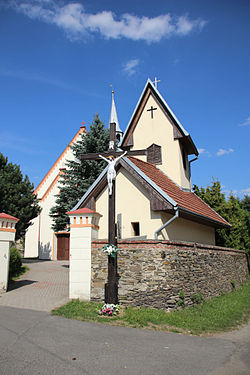
 St George's church | |
| Coordinates: 50°22′56″N 17°28′59″E / 50.38222°N 17.48306°E | |
| Country | |
| Voivodeship | Opole |
| County | Prudnik |
| Gmina | Prudnik |
| Highest elevation | 306 m (1,004 ft) |
| Lowest elevation | 250 m (820 ft) |
| Population | 451 |
| Time zone | UTC+1 (CET) |
| • Summer (DST) | UTC+2 (CEST) |
| Vehicle registration | OPR |

Mieszkowice [mjɛʂkɔˈvit͡sɛ] (German: Dittmannsdorf) is a village in the administrative district of Gmina Prudnik, within Prudnik County, Opole Voivodeship, in southern Poland, close to the Czech border.[1] It lies approximately 10 kilometres (6 mi) north-west of Prudnik and 45 km (28 mi) south-west of the regional capital Opole. Historically located in Upper Silesia, in the Prudnik Land.
The village had a population of 451 in 2011.[2] St George's Catholic church, originally built in the 16th century as a Lutheran church, was added to the Registry of Cultural Property on 15 January 1955.[3]
History
[edit]The village was founded, probably in the 13th century, as a forest village that was one of several German settlements in Upper Silesia.[4] Its name was recorded as Ditmarsdorff in 1464.[5] The region was part of the Duchy of Poland until the 14th century, when it was incorporated into the Kingdom of Bohemia. In 1742 it became part of the Kingdom of Prussia and in 1871, of the German Empire. In 1845, Dittmannsdorf had a population of 1,246, a Catholic church, Catholic and Lutheran schools;[5] in 1885, the population was 1,141.[6] In 1945, after the defeat of Germany in World War II, it again became part of Poland.
References
[edit]- ^ "Central Statistical Office (GUS) - TERYT (National Register of Territorial Land Apportionment Journal)" (in Polish). 1 June 2008.
- ^ "Ludność – struktura według ekonomicznych grup wieku" (in Polish). Central Statistical Office (Poland).
- ^ "Rejestr zabytków nieruchomych woj. opolskiego" (PDF) (in Polish). National Institute of Cultural Heritage. p. 111. Archived from the original (PDF) on 27 September 2013.
- ^ Walter Kuhn (1954). Siedlungsgeschichte Oberschlesiens (in German). Würzburg: Oberschleisischer Heimatverlag. p. 66. OCLC 7480437.
- ^ a b Johann G. Knie (1845). Alphabetisch-statistisch-topographische Uebersicht der Dörfer, Flecken, Städte und andern Orte der Königl. preuss. Provinz Schlesien (in German) (2nd ed.). Breslau: Graß, Barth & Co. p. 96. OCLC 17990713.
- ^ Gemeindelexikon für das Königreich Preußen: auf Grund der Materialien der Volkszählung vom 1. Dezember 1885 und anderer amtlicher Quellen (in German). Vol. 6 Provinz Schlesien. Berlin: Verlag des Königlichen Statistischen Bureaus. 1887. pp. 444–45. OCLC 257483962.
External links
[edit] Media related to Mieszkowice, Opole Voivodeship at Wikimedia Commons


