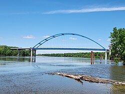
Meredosia Bridge
Appearance
Meredosia Bridge | |
|---|---|
 | |
| Coordinates | 39°49′51″N 90°33′57″W / 39.83073°N 90.56580°W |
| Carries | |
| Crosses | Illinois River |
| Locale | Meredosia, Illinois |
| Maintained by | Illinois DOT |
| ID number | 000069001615775 |
| Characteristics | |
| Design | Tied arch |
| Total length | 2,232 feet (0.4227 mi; 0.680 km)[1] |
| Clearance below | 72 feet (22 m)[1] |
| History | |
| Constructed by | Halverson Construction |
| Construction start | 2015 |
| Construction end | 2018 |
| Construction cost | $86.2 million |
| Opened | 2018[1] |
| Inaugurated | June 19, 2018 |
| Statistics | |
| Daily traffic | 2,400 (2005)[1] |
| Location | |
 | |
The Meredosia Bridge is a two-lane tied-arch bridge constructed in 2018 that carries Illinois Route 104 (IL 104) across the Illinois River between Pike County, Illinois and the city of Meredosia, Morgan County, Illinois.[1] The current bridge was built 250 feet (76 m) north of the old steel truss bridge.[2]
See also
[edit]References
[edit]- ^ a b c d e "Meredosia Bridge". Bridgehunter.com: Historic Bridges of the United States. James Baughn. Retrieved 2017-02-26.
- ^ Blanchette, David (2017-02-14). "Meet-in-the-middle bridge construction underway at Meredosia". The State Journal-Register. Retrieved 2018-01-10.
External links
[edit]
