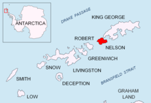
Meana Point

Meana Point (Bulgarian: нос Меана, romanized: nos Meana, IPA: [ˈnɔs mɛˈanɐ]) is the ice covered west entrance point of Quesada Cove on the north coast of Nelson Island in the South Shetland Islands, Antarctica. It is formed as a result of the retreat of Nelson Island's ice cap in the last decade of 20th century.[1] The area was visited by early 19th century sealers.[2]
The feature is named after Elias Meana Díaz, member of the Spanish team that built Juan Carlos I base in January 1988 and first commander of that base during the 1988/89 austral summer season, for his support for the Bulgarian Antarctic programme.[1]
Location
[edit]Meana Point is located at 62°14′39.5″S 59°05′27″W / 62.244306°S 59.09083°W, which is 1 km east of Baklan Point, 530 m south of Rotalia Island and 2.5 km southwest of Cariz Point. British mapping of the area in 1968.
Maps
[edit]- Livingston Island to King George Island. Scale 1:200000. Admiralty Nautical Chart 1776. Taunton: UK Hydrographic Office, 1968
- South Shetland Islands. Scale 1:200000 topographic map No. 3373. DOS 610 - W 62 58. Tolworth, UK, 1968
- Antarctic Digital Database (ADD). Scale 1:250000 topographic map of Antarctica. Scientific Committee on Antarctic Research (SCAR). Since 1993, regularly upgraded and updated
Notes
[edit]- ^ a b Meana Point. SCAR Composite Gazetteer of Antarctica
- ^ L. Ivanov. General Geography and History of Livingston Island. In: Bulgarian Antarctic Research: A Synthesis. Eds. C. Pimpirev and N. Chipev. Sofia: St. Kliment Ohridski University Press, 2015. pp. 17–28
References
[edit]- Meana Point. SCAR Composite Gazetteer of Antarctica.
- Bulgarian Antarctic Gazetteer. Antarctic Place-names Commission. (details in Bulgarian, basic data in English)
External links
[edit]- Meana Point. Copernix satellite image
This article includes information from the Antarctic Place-names Commission of Bulgaria which is used with permission.
