McLennan, Alberta
McLennan | |
|---|---|
Town | |
| Town of McLennan | |
 | |
| Nickname: | |
 Location in the MD of Smoky River No. 130 | |
| Coordinates: 55°42′42″N 116°54′34″W / 55.71167°N 116.90944°W | |
| Country | Canada |
| Province | Alberta |
| Region | Northern Alberta |
| Planning region | Upper Peace |
| Municipal district | Municipal District of Smoky River No. 130 |
| Incorporated[1] | |
| • Village | February 1, 1940 |
| • Town | February 11, 1950 |
| Government | |
| • Mayor | Jason Doris (Mayor) |
| • Governing body | McLennan Town Council |
| Area (2021)[3] | |
| • Land | 3.58 km2 (1.38 sq mi) |
| Elevation | 625 m (2,051 ft) |
| Population (2021)[3] | |
| • Total | 695 |
| • Density | 194.3/km2 (503/sq mi) |
| Time zone | UTC−7 (MST) |
| • Summer (DST) | UTC−6 (MDT) |
| Highways | Highway 2 |
| Waterway | Kimiwan Lake |
| Website | Official website |
McLennan is a town in northern Alberta, Canada. It is approximately 50 km (31 mi) north of High Prairie on Highway 2.
Named after John K. McLennan, vice president of the Edmonton, Dunvegan and British Columbia Railway on what used to be a community known as Round Lake,[5] the town lies on the southern shore of Kimiwan Lake (the Cree word for rain), and northwest of Winagami Lake. The large concentration of shorebirds and waterfowl and McLennan's informal nickname as the 'Bird Capital of Canada' is due to the nearby lakes creating an attraction for migratory birds.[6] Winagami Lake Provincial Park is located 29 km (18 mi) southeast of McLennan.
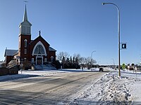
Its Cathédrale Saint-Jean-Baptiste, dedicated to John the Baptist, and built in 1947[7] is the archiepiscopal see of the Metropolitan Roman Catholic Archdiocese of Grouard–McLennan.
Demographics
[edit]In the 2021 Census of Population conducted by Statistics Canada, the Town of McLennan had a population of 695 living in 255 of its 322 total private dwellings, a change of -0.9% from its 2016 population of 701. With a land area of 3.58 km2 (1.38 sq mi), it had a population density of 194.1/km2 (502.8/sq mi) in 2021.[3]
In the 2016 Census of Population conducted by Statistics Canada, the Town of McLennan recorded a population of 701 living in 256 of its 296 total private dwellings, a -13.3% change from its 2011 population of 809. With a land area of 3.71 km2 (1.43 sq mi), it had a population density of 188.9/km2 (489.4/sq mi) in 2016.[16]
The population of the Town of McLennan according to its 2017 municipal census is 791.[17]
See also
[edit]References
[edit]- ^ "Location and History Profile: Town of McLennan" (PDF). Alberta Municipal Affairs. October 7, 2016. p. 393. Retrieved October 16, 2016.
- ^ "Municipal Officials Search". Alberta Municipal Affairs. May 9, 2019. Retrieved October 1, 2021.
- ^ a b c "Population and dwelling counts: Canada, provinces and territories, and census subdivisions (municipalities)". Statistics Canada. February 9, 2022. Retrieved February 9, 2022.
- ^ "Alberta Private Sewage Systems 2009 Standard of Practice Handbook: Appendix A.3 Alberta Design Data (A.3.A. Alberta Climate Design Data by Town)" (PDF) (PDF). Safety Codes Council. January 2012. pp. 212–215 (PDF pages 226–229). Retrieved October 8, 2013.
- ^ "Heritage and History". Town of McLennan Official Website. Retrieved 2020-11-12.
- ^ "Eco-Tourism". Town of McLennan Official Website. Retrieved 2020-11-12.
- ^ "Information on the Archdiocese is Grouard-McLennan". Roman Catholic Archdiocese of Grouard–McLennan. November 8, 2020. Retrieved November 8, 2020.
- ^ "Table 5: Population of urban centres, 1916-1946, with guide to locations". Census of the Prairie Provinces, 1946. Vol. I: Population. Ottawa: Dominion Bureau of Statistics. 1949. pp. 397–400.
- ^ "Table 6: Population by sex, for census subdivisions, 1956 and 1951". Census of Canada, 1956. Vol. I: Population. Ottawa: Dominion Bureau of Statistics. 1958.
- ^ "Table 9: Population by census subdivisions, 1966 by sex, and 1961". 1966 Census of Canada. Western Provinces. Vol. Population: Divisions and Subdivisions. Ottawa: Dominion Bureau of Statistics. 1967.
- ^ "Table 3: Population for census divisions and subdivisions, 1971 and 1976". 1976 Census of Canada. Census Divisions and Subdivisions, Western Provinces and the Territories. Vol. Population: Geographic Distributions. Ottawa: Statistics Canada. 1977.
- ^ "Table 2: Census Subdivisions in Alphabetical Order, Showing Population Rank, Canada, 1981". 1981 Census of Canada. Vol. Census subdivisions in decreasing population order. Ottawa: Statistics Canada. 1982. ISBN 0-660-51563-6.
- ^ "Table 2: Population and Dwelling Counts, for Census Divisions and Census Subdivisions, 1986 and 1991 – 100% Data". 91 Census. Vol. Population and Dwelling Counts – Census Divisions and Census Subdivisions. Ottawa: Statistics Canada. 1992. pp. 100–108. ISBN 0-660-57115-3.
- ^ "Population and Dwelling Counts, for Canada, Provinces and Territories, and Census Divisions, 2001 and 1996 Censuses – 100% Data (Alberta)". Statistics Canada. Retrieved 2019-05-25.
- ^ "Population and dwelling counts, for Canada, provinces and territories, and census subdivisions (municipalities), 2006 and 2001 censuses – 100% data (Alberta)". Statistics Canada. January 6, 2010. Retrieved 2019-05-25.
- ^ a b "Population and dwelling counts, for Canada, provinces and territories, and census subdivisions (municipalities), 2016 and 2011 censuses – 100% data (Alberta)". Statistics Canada. February 8, 2017. Retrieved February 8, 2017.
- ^ 2017 Municipal Affairs Population List (PDF). Alberta Municipal Affairs. ISBN 978-1-4601-3652-2. Retrieved January 13, 2018.

