Matong State Forest
| Matong State Forest | |
|---|---|
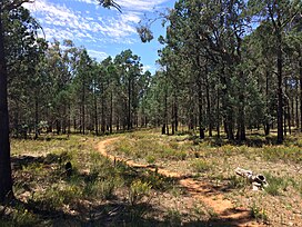
 White cypress pine forest | |
| Geography | |
| Location | South Western Slopes, New South Wales, Australia |
| Coordinates | 34°50′58″S 146°55′27″E / 34.84944°S 146.92417°E |
| Elevation | 160 metres (520 ft) - 170 metres (560 ft)[1] |
| Area | 3,177 ha (31.8 km2; 12.3 sq mi) |
| Administration | |
| Governing body | Forestry Corporation of NSW[2] |
| Ecology | |
| Dominant tree species | White cypress pine[3] |
| Lesser flora | Grey box, yellow box, river red gum, bulloak[1] |
Matong State Forest is a native forest, located in the South Western Slopes region of New South Wales, in eastern Australia. The 3,177 ha (7,850-acre)[2] state forest is located approximately 6 km (3.7 mi) south of Matong, and 30 km (19 mi) south-east of Narrandera.[4]
The Burning Seed Festival, an annual regional Burning Man event, has been held at the state forest since 2011.[5][6]
Etymology
[edit]The place name Matong is derived from a local Aboriginal word meaning 'strong' or 'great'.[7]
Environment
[edit]Flora
[edit]221 plant species have been recorded within the state forest, of which 135 were native, and 86 were introduced.[1] At least 94 percent of the forest within the state forest is dominated by white cypress pine.[3] Other large tree species present within the forest include grey box, yellow box, river red gum and bulloak.[1]
Native plant species recorded within the state forest include nardoo, rock fern, small vanilla lily, bulbine lily, early nancy, dusky fingers, common onion orchid, purple burr-daisy, climbing saltbush, twining glycine, showy wattle, Mallee wattle, hakea wattle, wedge-leaf hop-bush and creamy candles.[1]
Fauna
[edit]At least 10 species listed under the Biodiversity Conservation Act 2016 have been recorded within the state forest,[3] including brown treecreeper, diamond firetail, grey-crowned babbler and spotted harrier.[3] Other birds recorded in the state forest include rufous whistler and peaceful dove.[8]
See also
[edit]References
[edit]- ^ a b c d e Burrows, Geoff E. (1999). "A survey of 25 remnant vegetation sites in the South Western Slopes, New South Wales". Cunninghamia. 6 (2): 283–314.
- ^ a b "NSW State Forests" (PDF). Forestry Corporation. 17 March 2014. Archived (PDF) from the original on 5 March 2023. Retrieved 25 March 2023.
- ^ a b c d "Regional Forest Assessment: South-western cypress state forests" (PDF). Natural Resources Commission. Archived (PDF) from the original on 14 March 2023. Retrieved 25 March 2023.
- ^ "Forests NSW forest management zones - Riverina Region" (PDF). Forestry Corporation of NSW. January 2008. Archived (PDF) from the original on 7 March 2023. Retrieved 25 March 2023.
- ^ "Festival-goers to burn effigy". Australian Broadcasting Corporation. 10 November 2011. Retrieved 3 April 2023.
- ^ "Burning Seed". AnydayGuide. Retrieved 3 April 2023.
- ^ "Matong". Geographical Names Board of New South Wales. Retrieved 2 April 2023.
- ^ Schultz, Mike; Valenzisi, Tracey (2010). "Bird trails of the Riverina and South West Slopes of NSW" (PDF) (PDF). Riverina and South West Slopes Nature-Based Tourism Group. ISBN 978-0-646-53816-7. Retrieved 9 July 2024.
