Marokopa River
Appearance
(Redirected from Marokopa Falls)
| Marokopa River | |
|---|---|
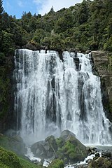
 Marokopa River at Marokopa Falls | |
 | |
| Location | |
| Country | New Zealand |
| Region | Waikato Region |
| Physical characteristics | |
| Source | |
| • location | Waitomo District |
| Mouth | |
• location | Tasman Sea |
• elevation | 0 m (0 ft) |
| Length | 40.5 km (25.2 mi) |
The Marokopa River is a river of the Waikato Region of New Zealand.[1] It flows west to join the Tasman Sea at Marokopa. The main part of the river is 40.5 km (25.2 mi) long, with about 533 km (331 mi) of tributaries. The catchment is some 364 km2 (141 sq mi).[2]
Near Te Anga, the river flows over the picturesque[3] Marokopa Falls. The settlements of Awamarino and Marokopa are located on the river's banks.
Trout were introduced about 1910.[4] The lower river is polluted.[5]
See also
[edit]References
[edit]- ^ "Place name detail: Marokopa River". New Zealand Gazetteer. New Zealand Geographic Board. Retrieved 23 April 2010.
- ^ "Environmental monitoring data for Marokopa River". Land, Air, Water Aotearoa (LAWA). Retrieved 10 March 2019.
- ^ Marokopa Falls walk ("often described as the most beautiful in the country", from the New Zealand Department of Conservation website. Accessed 2013-07-20.)
- ^ "King Country Chronicle, Local and General News". paperspast.natlib.govt.nz. 26 February 1910. Retrieved 10 March 2019.
- ^ "Marokopa River at Speedies Rd (Off Te Anga Rd) River Quality". Land, Air, Water Aotearoa (LAWA). Retrieved 10 March 2019.
38°18′26″S 174°42′56″E / 38.307235°S 174.715666°E
