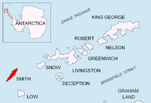
Markeli Point
Appearance


Markeli Point (Bulgarian: нос Маркели, ‘Nos Markeli’ \'nos mar-'ke-li\) is a point on the northwest coast of Smith Island in the South Shetland Islands, Antarctica, projecting 1.2 km west-southwestwards into Drake Passage. Situated on the north side of the entrance to Cabut Cove 14.5 km southwest of Cape Smith, 2 km south-southwest of Gregory Point and 19.8 km north-northeast of Cape James. Bulgarian early mapping in 2009. Named after the medieval fortress of Markeli in southeastern Bulgaria.
62°56′10″S 62°33′05″W / 62.93611°S 62.55139°W
References
[edit]- Bulgarian Antarctic Gazetteer. Antarctic Place-names Commission. (details in Bulgarian, basic data in English)
- Markeli Point. SCAR Composite Antarctic Gazetteer
External links
[edit]- Markeli Point. Copernix satellite image
This article includes information from the Antarctic Place-names Commission of Bulgaria which is used with permission.
