Margara
Appearance
(Redirected from Margara, Armenia)
40°02′01″N 44°10′26″E / 40.03361°N 44.17389°E
Margara
Մարգարա | |
|---|---|
| Coordinates: 40°02′01″N 44°10′26″E / 40.03361°N 44.17389°E | |
| Country | Armenia |
| Marz (Province) | Armavir |
| Population (2011) | |
• Total | 1,256[1] |
| Time zone | UTC+4 ( ) |
| • Summer (DST) | UTC+5 ( ) |

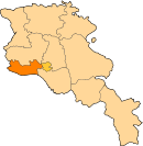
Margara (Armenian: Մարգարա, also Romanized as Markara; formerly Margara-Gök) is a town in the Armavir Province of Armenia. Margara is the closest border crossing to Turkey from Yerevan, though Turkey closed the border with Armenia in 1993.[2] The town is located on the other side of Alican. Margara has a road bridge across the Arax River to Turkey. The Border Guard Service of Russia patrols the closed border between Armenia and Turkey.
History
[edit]In 2023, the border crossing briefly reopened to allow the passage of humanitarian aid following the Turkey–Syria earthquake for the first time since 1988.[3]
See also
[edit]References
[edit]- ^ "Armavir (Armenia): Towns and Villages in Municipalities". www.citypopulation.de. Retrieved 2024-11-10.
- ^ "Margara crossing point at Armenian-Turkish border ready for use after repair". armenpress.am. 12 January 2024. Retrieved 2024-02-26.
- ^ "Armenia-Turkey border crossing opened for first time in 35 years after massive quake". AFP via Al Arabiya. 11 February 2023. Retrieved 13 February 2023.
External links
[edit]- Video about the Armenia-Turkey border at Margara by ArmeniaLiberty (RFE/RL)
- World Gazeteer: Armenia[dead link] – World-Gazetteer.com
- Report of the results of the 2001 Armenian Census, Statistical Committee of Armenia
- Margara at GEOnet Names Server
- Kiesling, Brady (June 2000). Rediscovering Armenia: An Archaeological/Touristic Gazetteer and Map Set for the Historical Monuments of Armenia (PDF). Archived (PDF) from the original on 6 November 2021.


