Maputsoe
Appearance
Maputsoe, Leribe | |
|---|---|
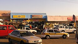
 Open air market in central Maputsoe. | |
 Location of Maputsoe in Lesotho. |
Maputsoe is a town and constituency located in the northern district of Leribe in Lesotho; it shares a border-post with Ficksburg in the Free State province of South Africa, with the Mohokare River forming the national boundary. It has a population of 55,541.
The Irish NGO 'Action Lesotho', which works in Maputsoe, was set up by politician Mannete Ramali, whilst she was Ambassador to Ireland.[1]
Villages
[edit]Maputsoe includes the villages of Mathata, Ha Nyenye (Ha Maputsoe, Khomo-lia-oela, Ha Chonapase, Phukalla, Mohalalitoe and Ha Maqele), Ha Motlalehi and Ha Chaka.[clarification needed]
References
[edit]- ^ "From one kingdom to another". www.irishexaminer.com. 23 May 2013. Retrieved 6 June 2020.
