Manja (district)
Appearance
(Redirected from Manja District)
Manja | |
|---|---|
| Coordinates: 21°26′S 44°20′E / 21.433°S 44.333°E | |
| Country | |
| Region | Menabe |
| District | Manja |
| Area | |
| • Total | 9,073 km2 (3,503 sq mi) |
| Elevation | 0- 350 m (−1,150 ft) |
| Population (2020) | |
| • Total | 111,430 |
| • Density | 12/km2 (32/sq mi) |
| Time zone | UTC3 (EAT) |
| Postal code | 616 |
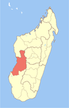
Manja is a district of Menabe in Madagascar[2][3] approximately 70 km in the south of the capitol Morondava. The district has an area of 9,073 km2 (3,503 sq mi), and the estimated population in 2020 was 111,430.[3]
Municipalities
[edit]The district is further divided into six communes:
Rivers
[edit]The Mangoky River in the south and the Sakalava River.
References
[edit]- ^ Estimated based on DEM data from Shuttle Radar Topography Mission
- ^ REPOBLIKAN'I MADAGASIKARA:Tanindrazana – Fahafahana – Fandrosoana (PDF). MINISTERE DE L’AGRICULTURE, DE L’ELEVAGE ET DE LA PECHE. October 2007. pp. 42–44. Archived from the original (PDF) on 2018-06-12. Retrieved 2018-06-09.
- ^ a b "Madagascar: Administrative Division". citypopulation. Retrieved 10 June 2018.


