Mangarongaro (Penrhyn)
Appearance

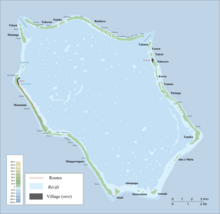
Mangarongaro is an islet in Penrhyn Atoll (Tongareva) in the Cook Islands, in the South Pacific Ocean.[1] Mangarongaro makes up most of the southwestern rim of the atoll, south of Moananui Islet and west of Atiati. The islet was once inhabited, and contains the remains of two marae, Rakahanga and Te Vete.[2]
References
[edit]- ^ Liu Chuang; Shi Ruixiang; Chen Lijun (January 2019). "Penrhyn Atoll". Institute of Geographical Sciences and Natural Resources Research, Chinese Academy of Sciences. Retrieved 10 August 2020.
- ^ Te Rangi Hiroa (April 1932). Ethnology of Tongareva. Honolulu: Bernice P. Bishop Museum. p. 171-172. Retrieved 21 August 2020 – via NZETC.
9°3′11.66″S 157°59′11.93″W / 9.0532389°S 157.9866472°W
