Mali i Gjerë
| Mali i Gjerë | |
|---|---|
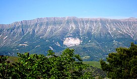
 View of Mali i Gjerë from Gjirokastër | |
| Highest point | |
| Elevation | 1,789 m (5,869 ft) |
| Prominence | 972 m (3,189 ft) |
| Isolation | 464 m (1,522 ft) |
| Coordinates | 40°05′20″N 20°03′44″E / 40.0889°N 20.062197°E |
| Naming | |
| English translation | Wide Mountain |
| Geography | |
| Country | |
| Region | Southern Mountain Region |
| Municipality | Gjirokastër, Sarandë, Delvinë |
| Parent range | Mali i Gjerë-Stugarë |
| Geology | |
| Rock age(s) | Mesozoic, Paleogene |
| Mountain type | massif |
| Rock type | limestone |
Mali i Gjerë (lit. 'Wide Mountain') is a massif located between the municipalities of Sarandë and Gjirokastër, in southern Albania. It constitutes the watershed boundary of the Delvina basin and the Drino valley as well as the waters that flow into the Adriatic and Ionian seas. The highest point is Maja e Frashërit, reaching a height of 1,789 m (5,869 ft). Other peaks include Maja e Kikshajt 1,782 m (5,846 ft), Maja e Nikollasit 1,584 m (5,197 ft), Maja e Bidos 1,543 m (5,062 ft), Maja e Pilloit 1,592 m (5,223 ft), etc.[1][2]
Etymology
[edit]The mountain is referred to as Mali i Gjerë in Albanian and as Platovouni (Greek: Πλατοβουνι) in Greek, and both names convey the same meaning of a broad or wide mountain.[3]
Geology
[edit]Mali i Gjerë stretches from the valley of Kardhiq in the northwest to Qafa e Muzinës 540 m (1,770 ft) in the south, at a length of about 30 km (19 mi). The massif is composed of Mesozoic and Paleogene limestone that form a large asymmetric anticlinal structure with a less steep eastern flank and a western flank separated by a tectonic overthrust. The watershed ridge as well as the wide eastern slope gently incline (hence the name), and are filled with various forms of karst erosion. The main passes are Muzina, Sopot and Skërficka.[4][5][6]
Biodiversity
[edit]At the southwestern and northeastern foothills are found a number of karst springs (Bistrica, Vërgoi, Viroi). The main tributary is sourced from a well-known karst spring called the Blue Eye (Albanian: Syri i Kaltër), which is a popular tourist attraction due to its scenic environment. Woodland is scarce, but the area is rich in summer pastures and several types of medicinal plants (tea, orchid, hawthorn, yarrow, oregano). Among the wild animals, the mountain partridge is commonly encountered.
The eastern slope of the mountain is surrounded by the nearby settlements of Gjirokastër, Lower Dropull, Lazarat, and Mashkullore, while on the western slope are situated Delvina and the villages of Rrëzoma.[7]
The karst massif spreads mostly within Albania, covering about 440 km2 (170 sq mi), with 54 km2 (21 sq mi) extending into the Greek territory.[8]
Human History
[edit]In antiquity, the Mali i Gjerë range divided the territory of the ancient Greek tribe of the Chaonians in two parts; the western part centered around Phoenice and the eastern one centered around Antigonea.[9]
See also
[edit]References
[edit]- ^ Kabo, Mevlan (1991). Gjeografia Fizike e Shqipërisë (1.2 ed.). Tiranë: Qendra e Studimeve Gjeografike. p. 373–375.
- ^ Celet, Paul (2012) [1977]. "The geology of the Adriatic". In Alan Nairn (ed.). The Ocean Basins and Margins: Volume 4A The Eastern Mediterranean. Springer Science & Business Media. p. 226. ISBN 9781468430363.
Stratigraphy. Upper Triassic (Norian)—Lower Triassic dolomites, with intercalated lenticular bituminous horizons in the Iower part, crop out in the center of the Albanian Ionian zone (Mali Gjere Mountains). In Greece, Norian dolomites rest upon black limestones with Cardita gumbeli assigned to the Carnian (I.F.P.—I.G.R.S., 1966).
- ^ Giakoumis, Konstantinos (2021). Monastic Financial Management in the Provinces of the Patriarchate of Constantinople (1867–1873) (PDF). Sofia: Centre for Advanced Study Sofia. p. 137.
- ^ Buda, Aleks (1985). Fjalori Enciklopedik Shqiptar. Tiranë: Akademia e Shkencave e RPSSH. p. 662.
- ^ Celet, Paul (2012) [1977]. "The geology of the Adriatic". In Alan Nairn (ed.). The Ocean Basins and Margins: Volume 4A The Eastern Mediterranean. Springer Science & Business Media. p. 226. ISBN 9781468430363.
Stratigraphy. Upper Triassic (Norian)—Lower Triassic dolomites, with intercalated lenticular bituminous horizons in the Iower part, crop out in the center of the Albanian Ionian zone (Mali Gjere Mountains). In Greece, Norian dolomites rest upon black limestones with Cardita gumbeli assigned to the Carnian (I.F.P.—I.G.R.S., 1966).
- ^ Budina, Dhimosten (1971). "Strukturat gjeologjike". Iliria (v. 1). Universiteti i Tiranës, Sektori i Arkeologjisë.: 267.
Kufirin lindor të kësaj zone e formojnë Mali i Gjerë, Qafa e Muzinës dhe vargu i maleve në jug të saj, deri në Stugare
- ^ Bërzholi, Arqile (2015). "Treva e Gjirokastrës, veçoritë e popullit dhe të dinamikës ekonomike" (PDF). Demografia (in Albanian) (1): 45. ISSN 2308-6491.
- ^ Eftimi, Romeo; Andreychouk, Viacheslav; Szczypek, Tadeusz; Puchejda, Wojciech (1 January 2019). "Karst springs of Albania and their management". KIP Articles: 49. Retrieved 29 March 2023.
- ^ De Maria, Sandro; Bogdani, Jylian; Giorgi, Enrico (2017). "Ricerca e tutela in un territorio di frontiera. L'Epiro del Nord fra età ellenistica e presenza di Roma". In Gianluca Mastrocinque (ed.). Paesaggi mediterranei di età romana. Archeologia, tutela, comunicazione. Bibliotheca archaeologica. Vol. 47. Edipuglia. p. 56. doi:10.4475/835. ISBN 978-88-7228-835-1. ISSN 1724-8523.

