Malé Leváre
Appearance
Malé Leváre
Kislévárd | |
|---|---|
 Church in Malé Leváre | |
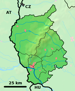
Location of Malé Leváre in the Bratislava Region Location of Malé Leváre in Slovakia | |
| Coordinates: 48°30′N 16°58′E / 48.50°N 16.97°E | |
| Country | |
| Region | |
| District | Malacky District |
| First mentioned | 1378 |
| Area | |
• Total | 21.40 km2 (8.26 sq mi) |
| Elevation | 153 m (502 ft) |
| Population (2021)[3] | |
• Total | 1,755 |
| Time zone | UTC+1 (CET) |
| • Summer (DST) | UTC+2 (CEST) |
| Postal code | 908 74[2] |
| Area code | +421 34[2] |
| Car plate | MA |
| Website | www |
Malé Leváre (Hungarian: Kislévárd) is a village and municipality in western Slovakia in Malacky District in the Bratislava region, near the border with Austria.
It was mentioned for the first time in deed from the year 1377, issued by the king Louis I. of Hungary. Village is dominated by renaissance, baroque rebuilt Roman Catholic church of Assumption of the Holy Virgin. In the area of the village there is also a baroque chapel, and bunkers, which were built as part of Czechoslovak border fortification in 1938. During the Cold War, the Iron Curtain was leading near the village and the border was guarded by soldiers.
References
[edit]- ^ "Hustota obyvateľstva - obce [om7014rr_ukaz: Rozloha (Štvorcový meter)]". www.statistics.sk (in Slovak). Statistical Office of the Slovak Republic. 2022-03-31. Retrieved 2022-03-31.
- ^ a b c "Základná charakteristika". www.statistics.sk (in Slovak). Statistical Office of the Slovak Republic. 2015-04-17. Retrieved 2022-03-31.
- ^ "Počet obyvateľov podľa pohlavia - obce (ročne)". www.statistics.sk (in Slovak). Statistical Office of the Slovak Republic. 2022-03-31. Retrieved 2022-03-31.


