Machikou
Appearance
Machikou Area
马池口地区 Machikou Town (马池口镇) | |
|---|---|
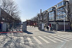
 East Gate, New Changping Campus of Peking University, 2022 | |
 Location of Machikou Area within Changping District | |
| Coordinates: 40°10′59″N 116°09′38″E / 40.18306°N 116.16056°E | |
| Country | China |
| Municipality | Beijing |
| District | Changping |
| Village-level Divisions | 1 community 21 villages |
| Area | |
• Total | 61.8 km2 (23.9 sq mi) |
| Elevation | 57 m (187 ft) |
| Population (2020) | |
• Total | 87,506 |
| • Density | 1,400/km2 (3,700/sq mi) |
| Time zone | UTC+8 (China Standard) |
| Postal code | 102299 |
| Area code | 010 |
Machikou Area (simplified Chinese: 马池口地区; traditional Chinese: 馬池口地區; pinyin: Mǎchíkǒu Dìqū) is an area and a town inside of Changping District, Beijing, China. Machikou shares border with Chengnan and Chengbei Subdistricts to its north, Nanshao and Shahe Towns to its east, Shangzhuang and Yangfang Towns to its south, and Nankou Town to its west and north. The population for this area was 87,506 as of 2020.[1]
This area's name Machikou (Chinese: 马池口; lit. 'Horse Pool Mouth') is referring to the region's past location as a stopping for trading caravans.[2]
History
[edit]| Year | Status | Under |
|---|---|---|
| 1949–1953 | 1st District | Changping County |
| 1953–1956 | Split into 5 townships:
| |
| 1956–1958 | Machikou Township | |
| 1958–1959 | Machikou Working Station, within Shisanling People's Commune | |
| 1959–1961 | Machikou Production Team, within Chengguan People's Commune | |
| 1961–1982 | Machikou People's Commune | |
| 1982–1990 | Machikou Township | |
| 1990–1999 | Machikou Town (Merged with part of Tingzizhuang Township in 1997, Tulou and Ge villages in 1998) | |
| 1999–present | Changping District |
Administrative divisions
[edit]As of the year 2021, Machikou Area had 22 subdivisions, in which 1 was a community, and 21 were villages:[3]
| Administrative Division Code | Subdisvision Names | Name Transliterations | Type |
|---|---|---|---|
| 110114003001 | 念头 | Niantou | Community |
| 110114003201 | 马池口 | Machikou | Village |
| 110114003202 | 东坨 | Dongtuo | Village |
| 110114003203 | 西坨 | Xituo | Village |
| 110114003204 | 东闸 | Dongzha | Village |
| 110114003205 | 北庄户 | Beizhuanghu | Village |
| 110114003206 | 楼自庄 | Louzizhaung | Village |
| 110114003207 | 土城 | Tucheng | Village |
| 110114003208 | 横桥 | Hengqiao | Village |
| 110114003209 | 白浮 | Baifu | Village |
| 110114003210 | 下念头 | Xia Niantou | Village |
| 110114003211 | 宏道 | Hongdao | Village |
| 110114003212 | 上念头 | Shang Niantou | Village |
| 110114003213 | 百泉庄 | Baiquanzhuang | Village |
| 110114003214 | 奤夿屯 | Habatun | Village |
| 110114003215 | 亭自庄 | Tingzizhuang | Village |
| 110114003216 | 北小营 | Beixiaoying | Village |
| 110114003217 | 乃干屯 | Naigantun | Village |
| 110114003218 | 丈头 | Zhangtou | Village |
| 110114003219 | 辛店 | Xindian | Village |
| 110114003220 | 土楼 | Tulou | Village |
| 110114003221 | 葛村 | Gecun | Village |
Gallery
[edit]-
Changping Experimental Base Institute of Crop Sciences, 2022
See also
[edit]References
[edit]- ^ "北京市昌平区第七次全国人口普查公报". bj.bjd.com.cn (in Chinese (China)). Retrieved 2022-10-18.
- ^ a b 李立国; 李万钧; 吴世民, eds. (2013). 中华人民共和国政区大典, 北京市卷. Beijing: 中国社会出版社. ISBN 978-7-5087-4058-4. OCLC 910451741.
- ^ "2021年统计用区划代码和城乡划分代码". www.stats.gov.cn. Retrieved 2022-10-19.
![]() Media related to Machikou at Wikimedia Commons
Media related to Machikou at Wikimedia Commons


