Malé
Malé
މާލެ | |
|---|---|
| Malé City | |
 | |
| Coordinates: 4°10′31″N 73°30′32″E / 4.17528°N 73.50889°E | |
| Country | |
| Geographic atoll | North Malé Atoll |
| Government | |
| • Type | Mayor-council |
| • Body | Malé City Council |
| • Mayor | Adam Azim (MDP) |
| Area | |
| 11.22 km2 (4.33 sq mi) | |
| • Urban | 1.95 km2 (0.75 sq mi) |
| • Metro | 9.27 km2 (3.58 sq mi) |
| Metro area also includes Hulhulé and Hulhumalé. | |
| Elevation | 2.4 m (7.9 ft) |
| Population (2022)[1] | |
| 211,908 | |
| • Density | 19,000/km2 (49,000/sq mi) |
| Time zone | UTC+5 (MVT) |
| Assigned Letter | T |
| Area code(s) | 331, 332, 333, 334 |
| ISO 3166 code | MV-MLE |
| Website | malecity.gov.mv |
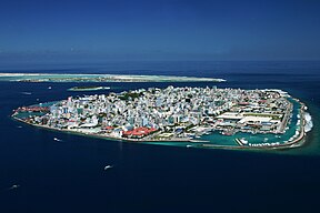
Malé[a] is the capital and most populous city of the Maldives. With a population of 211,908 in 2022[1] within its administrative area and coterminous geographical area of 8.30 square kilometres (3.20 sq mi), Malé is also one of the most densely populated cities in the world.[2][3] The city is geographically located in the southern edge of North Malé Atoll (Kaafu Atoll).[4]
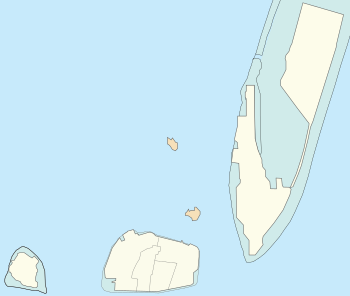
Administratively, the city consists of a central island, an airport island, and four other islands presided over by the Malé City Council.
Traditionally it was the King's Island, from where the ancient royal dynasties ruled and where the palace was located. The city was then called Mahal.[5] Formerly it was a walled city surrounded by fortifications and gates (doroshi). The Royal Palace (Gan'duvaru) was destroyed along with the picturesque forts (koshi) and bastions (buruzu) when the city was remodelled under President Ibrahim Nasir's rule in the aftermath of the abolition of the monarchy in 1968. However, some buildings remained, namely, the Malé Friday Mosque. In the last few decades, the island has been considerably expanded in size through land reclamation. Over the years, Malé has been the center of political protests and milestone events.
Overview
[edit]
Although Malé is geographically located in Kaafu Atoll, administratively it is not considered part of it.
Islands of Malé City
[edit]- Malé Central Island
- Hulhulé (Airport Island)
- Hulhumalé
- Villimalé
- Thilafushi
- Gulhifalhu
The central part of the city is formed by the island of Malé. Five more islands form part of the city which includes Hulhulé, Hulhumalé, Villimalé, Gulhifalhu and Thilafushi.
A commercial harbour is located on the central island and serves as the heart of all commercial activities in the country. Velana International Airport is located on the Island of Hulhulé.[6]
The central island is heavily urbanised, with the built-up area taking up essentially its entire landmass.[6] Slightly less than one third of the nation's population lives in the capital city, and the population has increased from 20,000 people in 1987 to 100,000 people in 2006. Many Maldivians and foreign workers living in other parts of the country find themselves in occasional short term residence on the island since it is the centre of administration and bureaucracy. Most of the population of Malé live in small houses or apartment complexes, often shared with external family or roommates. This led to the development of Hulhumalé and the extension to Phase 2.
The Indian expatriate community in the Maldives stands as the second-largest, comprising around 27,000 individuals. Among them, a substantial portion consists of construction workers, doctors, nurses, health professionals, and teachers, who play vital roles in the Maldivian infrastructure, healthcare and education sectors. Additionally, Indian and Bangladeshi nationals contribute significantly as skilled workers, alongside a sizable presence of unskilled laborers, as well as other professionals and members of the business community.[7]
History
[edit]The whole island group, the Maldives, is named after its capital. The word "Maldives" means "the islands (dives) of Malé".[8]
The first settlers in the Maldivian islands were Dravidian people[9] who arrived from the neighboring shores of the modern Indian subcontinent and coastal Ceylon. Comparative studies of Maldivian linguistic, oral, and other cultural traditions, in addition to folklore, point to a strong Dravidian influence on Maldivian society, centered in Malé, from ancient times. The Giraavaru people of Giraavaru claim descent from the first Tamil settlers of the Maldives.[10]
It is said that early Tamil settlers called the islands Maalaitivu, which means Garland Islands or Chain Islands. Early records also indicate that the island was called "Athamana Huraa" prior to being named Malé. According to regional lore, Giraavaru fishermen used to go regularly to a certain large sandbank (finolhu) at the southern end of their atoll to clean tuna fish after a good catch. Owing to the large amount of tuna fish offal and blood, the waters around that sandbank looked like a big pool of blood ("maa ley gandeh": "maa" from the Sanskrit मह "maha", meaning big, and "lē" blood). Traditionally the first inhabitants of the Maldives, which include the Giravaru people, did not have kings. They lived in a simple society and were ruled by local headmen.[citation needed]
However, one day, a prince from the subcontinent called Koimala arrived in the Malé Atoll sailing from the North on a big ship. The people of Giraavaru spotted his vessel from afar and welcomed him. They allowed Prince Koimala to settle on that large sandbank in the midst of the waters tainted with fish blood. Trees were planted on the sandbank and it is said that the first tree that grew on it was the papaya tree. (However, this could refer to any tree that bears edible fruit as the archaic Dhivehi word, and Mahal word in modern times, for fruit (falhoa) was the same as that for the papaya.[11]) As time went by, the local islanders accepted the rule of this Northern Prince. A palace was built and the island was formally named Maa-le (Malé), while the nearest island was named Hulhu-le.[citation needed]
The names of the main four wards or divisions of Malé Island are said to have been given by the original Giraavaru fishermen: Maafannu from maa (big) and fannu (a place where a village path meets the sea), Henveiru from en-beyru (out where fishermen got their bait), Galolhu from galu-olhu (stone groove) and, Macchangolhi from mathi-angolhi (windward path-fork).[citation needed]
In early foreign sources, Malé was called Ambria or Mahl.[citation needed] For the Maldivians, it was Fura Malé, i.e. "Malé the Pre-Eminent".[12]
When Ibn Battuta traveled to Malé in 1343 (in Arabic: المَحَل, romanized: al-Maḥal thus the entire Maldivian islands were ذِيبَةُ المَحَل Dhībat-ul-Maḥal[13]), he provided a rather extensive description of the city as well as the Islands of the Maldives overall. He mentioned that the Queen, Rehendhi Khadeeja, had a residence in Malé, which from its description may be assimilated to the same palace of the later sultan rulers, in the centre of the island.[14] Within the palace compounds, several pits contained stores of cowrie shells, ready to be traded. Ibn Battuta also mentioned several mosques, built in wood.[12]
Malé was fortified in the 17th century by the sultan Muhammad Imaduddin, who built walls on the north, east and west side of the island. An inner harbour was used by fishing vessels and small dhonis, while larger vessels had to anchor in the outer harbour, between the islands of Vilingili and Hulhule. The island covered less than one square mile in size, and was surrounded by a shallow lagoon.[12]
Malé had 2,148 inhabitants in 1888, but population growth soon led to the search for new spaces for housing. The old forts and decrepit walls were dismantled in 1925–1927 under the reign of Muhammad Shamsuddeen III, to be rebuilt on a smaller scale. Roads were also widened and straightened. Former large cemeteries had also been cleared out, to achieve more housing space.
The Royal Palace (Gan'duvaru) was destroyed along with the picturesque forts (koshi) and bastions (buruzu) when the city was remodelled under President Ibrahim Nasir's rule in the aftermath of the abolition of the monarchy in 1968. Only the National Museum building, residence of the last sultan, as well as the Malé Friday Mosque, remain. Malé's residents soon grew to 11,453 by 1967 and 29,522 by 1977. In order to cater for the growing population, by 1986 the shallow lagoon around Malé was reclaimed.[12]
The most revered place in Malé is the Medhu Ziyaaraiy, across the street from the Malé Friday Mosque: the tomb of Abu al-Barakat Yusuf al-Barbari, considered to have converted the Maldives to Islam in 1153.
-
Malé, Medhu Ziyaaraiy, 1958
-
Malé, Bodu Buruzu, 1960
-
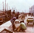
Malé beachfront, 1984
-
Malé beachfront, 1984
Geography
[edit]Climate
[edit]Malé has a tropical monsoon climate (Am) under the Köppen climate classification.[citation needed] The city features a mix of both wet and dry seasons, with the wet season lasting from April through January and the drier season covering the months of February and March. Unlike a number of cities with this climate, Malé experiences relatively consistent temperatures throughout the course of the year, with an average high of 30 °C or 86 °F and an average low of 26.5 °C or 79.7 °F, which is equivalent to many equatorial cities' average year-round daily mean. The city averages slightly more than 1,900 millimetres or 75 inches of precipitation annually. The temperature is constantly high year-round due in part to the Maldives having the lowest median elevation anywhere in the world.[citation needed]
| Climate data for Malé (Velana International Airport) 1991–2020, extremes 1966–present | |||||||||||||
|---|---|---|---|---|---|---|---|---|---|---|---|---|---|
| Month | Jan | Feb | Mar | Apr | May | Jun | Jul | Aug | Sep | Oct | Nov | Dec | Year |
| Record high °C (°F) | 32.8 (91.0) |
33.6 (92.5) |
33.5 (92.3) |
35.0 (95.0) |
34.2 (93.6) |
34.9 (94.8) |
34.2 (93.6) |
33.4 (92.1) |
33.4 (92.1) |
33.8 (92.8) |
32.7 (90.9) |
33.5 (92.3) |
35.0 (95.0) |
| Mean daily maximum °C (°F) | 30.6 (87.1) |
31.0 (87.8) |
31.6 (88.9) |
31.9 (89.4) |
31.5 (88.7) |
31.1 (88.0) |
30.8 (87.4) |
30.7 (87.3) |
30.5 (86.9) |
30.5 (86.9) |
30.4 (86.7) |
30.4 (86.7) |
30.9 (87.6) |
| Daily mean °C (°F) | 28.2 (82.8) |
28.6 (83.5) |
29.2 (84.6) |
29.6 (85.3) |
29.3 (84.7) |
29.0 (84.2) |
28.7 (83.7) |
28.6 (83.5) |
28.4 (83.1) |
28.3 (82.9) |
28.1 (82.6) |
28.0 (82.4) |
28.7 (83.7) |
| Mean daily minimum °C (°F) | 26.0 (78.8) |
26.3 (79.3) |
26.8 (80.2) |
27.1 (80.8) |
26.6 (79.9) |
26.4 (79.5) |
25.9 (78.6) |
25.9 (78.6) |
25.7 (78.3) |
25.7 (78.3) |
25.5 (77.9) |
25.6 (78.1) |
26.1 (79.0) |
| Record low °C (°F) | 20.6 (69.1) |
22.6 (72.7) |
22.4 (72.3) |
21.8 (71.2) |
20.6 (69.1) |
22.1 (71.8) |
22.5 (72.5) |
21.0 (69.8) |
20.5 (68.9) |
22.5 (72.5) |
19.2 (66.6) |
22.0 (71.6) |
19.2 (66.6) |
| Average rainfall mm (inches) | 86.8 (3.42) |
37.9 (1.49) |
48.6 (1.91) |
127.2 (5.01) |
238.2 (9.38) |
146.1 (5.75) |
198.1 (7.80) |
193.2 (7.61) |
213.7 (8.41) |
245.4 (9.66) |
235.6 (9.28) |
212.2 (8.35) |
1,983 (78.07) |
| Average rainy days (≥ 1.0 mm) | 5.5 | 3.2 | 4.5 | 8.5 | 15.0 | 12.9 | 13.7 | 13.0 | 15.3 | 15.2 | 14.2 | 12.0 | 133.0 |
| Average relative humidity (%) | 78 | 76 | 76 | 78 | 80 | 80 | 79 | 80 | 80 | 80 | 81 | 80 | 79 |
| Mean monthly sunshine hours | 258.4 | 263.5 | 287.9 | 259.6 | 222.6 | 210.5 | 212.4 | 229.1 | 208.1 | 229.8 | 203.8 | 215.1 | 2,800.8 |
| Source 1: World Meteorological Organization (humidity 1981-2010)[15][16] | |||||||||||||
| Source 2: Meteo Climat (record highs and lows)[17] | |||||||||||||
Subdivisions
[edit]The city is divided into six divisions, four of which are on Malé Island: Henveiru, Galolhu, Maafannu and MacchanGoalhi. The nearby island of Villimalé, formerly a tourist resort and prior to that a prison, is the fifth division. The sixth division is Hulhumalé, an artificial island settled since 2004. In addition, the airport Island Hulhulé is part of the city. Plans have been made to develop the Gulhifalhu reef, implementation began in 2008.[18][19][20]
|

Hen.
Gal.
Mac.
Maa.
← Gulhi Falhu
Dho.
Fun.
Gal. = 1 Galolhu
Hen. = 2 Henveiru
Maa. = 3 Maafannu
Mac. = 4 Machchangolhi
not part of Malé City:
Dho. = Dhoonidhoo (Prison Island)
Fun. = Funadhoo
|

The island of Malé is the eighth most densely populated island in the world, and it is the 160th most populous island in the world. Since there is no surrounding countryside, all infrastructure has to be located in the city itself. Water is provided from desalinated ground water; the water works pumps brackish water from 50–60 m (160–200 ft) deep wells in the city and desalinates that using reverse osmosis.[21] Electric power is generated in the city using diesel generators.[22] Sewage is pumped unprocessed into the sea.[21] Solid waste is transported to nearby islands, where it is used to fill in lagoons. The airport was built in this way, and currently the Thilafushi lagoon is being filled in.[23][24]
Many government buildings and agencies are located on the waterfront. Velana International Airport is on adjacent Hulhulé Island which includes a seaplane base for internal transportation. Several land reclamation projects have expanded the harbour.
Economy
[edit]
Tourism is the largest industry in the Maldives, accounting for 28% of GDP and more than 60% of the Maldives' foreign exchange receipts. The GDP per capita expanded by 265% in the 1980s and a further 115% in the 1990s. Over 90% of government tax revenue comes from import duties and tourism-related taxes. Malé, the capital, has many tourist attractions and nearby resorts. Maldivian, the airline of the Maldives, has its head office in Malé,[25] as does the airline Villa Air.[26]
The central harbour and port of the Maldives is located in Malé, the centre for all commercial activities. The Maldives Transport and Contracting Company (MTCC) is formed in 1980 to contribute towards the development of infrastructure and transport service in the Maldives. The port is part of the 21st Century Maritime Silk Road that runs from the Chinese coast via the Suez Canal to the Mediterranean, there to the Upper Adriatic region with its rail connections to Central and Eastern Europe.[27][28][29]
Transport
[edit]
Road
[edit]Each of the islands of Malé is served by a dense network of paved roads, which are named magu (road or street), hingun and goalhi (small road or alley). Road traffic is heavy, especially on Malé Island.
Malé and Hulhulé Island are linked by the Sinamalé Bridge, which was opened to traffic in October 2018, while Hulhulé and Hulhumalé are linked via a causeway, thus allowing the road networks of the three islands to be connected.
Public transport
[edit]

Public transport in Malé primarily consists of 3 minibus lines that run through the city, and connecting the Greater Malé region to the main island. All the routes are operated by Raajje Transport Link (RTL). These busses go through the wider roads through the city. Children under 18, people with special needs and people above 65 years of age ride for free.
The Orchid Route (R10), the Ameenee Route (R11) and the Sosun Route (R12). The routes are named after the main roads that the minibus drives through in Malé, being Orchid Magu, Ameenee Magu and Sosun Magu. The Malé system has a total of 41 stops, of which R10 and R11 stop at 20 each, while R12 stops at 8. All 3 routes go through Majeedhee Magu, in the centre of the city.
R11 to R9 are various routes connecting Malé to Hulhumalé and Velana International Airport. These busses are much larger, and in late 2020, began operating double-decker busses to Hulhumalé. The busses move between the islands using the Sinamalé Bridge.
R13 Is an internal minibus route located internally within Villimalé, and goes through 13 stops. It uses much smaller electrical-powered busses along with the Sosun Route (R12).[30]
Air
[edit]

Velana International Airport is located on nearby Hulhulé and is the city's airport as well as the principal airport in Maldives. With the opening of the Sinamalé Bridge, the airport is now accessible from Malé by road. Prior to the opening of the bridge, transport between the airport and Malé was by a frequent ferry service. Hulhulé and Hulhumalé have been connected via a causeway since the development of Hulhumalé, allowing the airport to be accessed by road from the latter.
Inter-island transport
[edit]As Malé, Hulhulé and Hulhumalé are now linked by roads, inter-island travel between the three islands can be done by road. For the other islands, inter-island transport is by ferry.
Port
[edit]
Malé island has a port that allows cargo vessels to dock.
Government
[edit]
City Council
[edit]Malé City Council is the local government body responsible for the governance of the city of Malé. The council was created in 2011, with the enactment of the Decentralization Bill. The city is divided into 18 political wards each with one councillor.
In the Local Council Elections in 2021, the mayor was elected for the first time ever, with Mohamed Muizzu being elected to the position. The Progressive Party of the Maldives picked up 11 seats while the Maldivian Democratic Party picked up 6 seats.[31][32] But due to Muizzu being elected as the President of the Maldives he resigned.[33] After Muizzu resigned the council ran a mayor election and Adam Azim was elected.[34]
Notable people
[edit]See also
[edit]- Hulhumalé artificial island
- Hulhulé Island, where Velana International Airport is located
- Malé Friday Mosque
- Lonuziyaaraiy Park
References
[edit]- ^ a b "Census Results Summary". Maldives Bureau of Statistics. Archived from the original on 1 September 2023. Retrieved 30 November 2023.
- ^ "The population density of Malé". Ministry of Environment, Climate Change and Technology. Archived (PDF) from the original on 14 March 2024. Retrieved 29 May 2022.
- ^ Zahir, Maeed M. "Population explosion; a major environmental issue in Male'". ECOCARE Maldives. Archived from the original on 3 March 2012. Retrieved 23 May 2015.
- ^ "Silver Marlin, Maldives - About Maldives". Silver Marlin. Archived from the original on 5 November 2015. Retrieved 23 May 2015.
- ^ Mohamed, Naseema. "Names of Maldives" (PDF). National Centre for Linguistic and Historical Research. Archived from the original on 7 April 2016. Retrieved 23 May 2015.
- ^ a b National Imagery and Mapping Agency (US) (2002). "Sector 5. The Laccadive Islands and the Maldive Islands". Sailing Directions (Enroute): India and the Bay of Bengal (PDF). United States Navy Publication 173 (seventh ed.). Bethesda, Maryland: United States National Imagery and Mapping Agency. pp. 109–110. Archived (PDF) from the original on 1 February 2017.
- ^ "India‐Maldives Bilateral Relations" (PDF). Ministry of External Affairs (India). July 2022. Archived (PDF) from the original on 2 May 2023. Retrieved 21 July 2023.
- ^ Caldwell, Comparative Dravidian Grammar, pp. 27–28
- ^ Xavier Romero-Frias, The Maldive Islanders, A Study of the Popular Culture of an Ancient Ocean Kingdom
- ^ Maloney, Clarence (1995). "Where Did the Maldives People Come From?". IIAS Newsletter (5). International Institute for Asian Studies. Archived from the original on 29 January 2002. Retrieved 22 June 2008.
- ^ A Concise Etymological Vocabulary of Dhivehi Language. Hasan A. Maniku. Speedmark. Colombo. 2000
- ^ a b c d Mohamed, Naseema (7 February 2008). "Fura Malé" (PDF). National Centre for Linguistics and Historical Research. Archived (PDF) from the original on 26 October 2022. Retrieved 21 May 2024.
- ^ Mahdi Husain, ed. (1953). The Rehla Of Ibn Battuta (India, Maldive Islands and Ceylon). Baroda: Oriental Institute. p. 197-8.
- ^ ibid., pp. 204-5.
- ^ "World Meteorological Organization Climate Normals for 1981–2010". World Meteorological Organization. Archived from the original on 9 October 2021. Retrieved 9 October 2021.
- ^ "Hulhule Climate Normals 1991–2020". National Oceanic and Atmospheric Administration. Archived from the original on 29 February 2024. Retrieved 29 February 2024.
- ^ "Station Malé" (in French). Meteo Climat. Archived from the original on 10 May 2017. Retrieved 9 January 2022.
- ^ "Gulhi Falhu project to begin early 2008". Miadhu Daily. Male'. 7 October 2007. Archived from the original on 26 May 2014.
- ^ "Pres. visits Gulhi Falhu". Miadhu Daily. Male'. 28 December 2010. Archived from the original on 28 December 2010. Retrieved 26 May 2014.
- ^ "Maldives first amusement park opens in Gulhi Falhu". Minivan News. Male'. 1 December 2013. Archived from the original on 26 May 2014. Retrieved 26 May 2014.
- ^ a b "Malé Water & Sewage FAQ". Male' Water and Sewerage Company. Archived from the original on 11 January 2008.
- ^ "Corporate Profile". State Electric Company Limited. Archived from the original on 16 November 2007.
- ^ "Management of Solid Waste and Sewage" (PDF). United Nations Environment Programme. Archived from the original (PDF) on 24 March 2012.
- ^ Waheed, Abdullah. "Gold in Garbage — the Experience from Maldives" (PDF). World Health Organization. Archived from the original (PDF) on 1 July 2007.
- ^ "Contact Us". Maldivian (airline). Retrieved 21 May 2024.
Corporate Head Office, Ground Floor, Dar Al-Eiman Building, Majeedhee Magu, Male, Zip Code 20345, Maldives
- ^ "Help & Support". Flyme (Villa Air). Retrieved 21 May 2024.
- ^ "Chinese president wins Maldives backing for 'maritime silk route'". Arab News. Agence France-Presse. 10 September 2014. Archived from the original on 15 July 2021. Retrieved 21 May 2024.
- ^ "Maldives signs up for China's Maritime Silk Road". The Economic Times. Press Trust of India. 18 December 2014. Archived from the original on 7 February 2021. Retrieved 21 May 2024.
- ^ Patranobis, Sutirtho (15 September 2014). "Xi wins Malé's backing for 'maritime silk route'". Hindustan Times. Archived from the original on 15 July 2021. Retrieved 21 May 2024.
- ^ Faaiq, Ali (7 November 2022). "Electric busses brought for RTL minibus fleet". The Times of Addu. Archived from the original on 26 November 2023. Retrieved 26 November 2023.
- ^ "Local Council Elections". SunOnline International. Archived from the original on 23 December 2021. Retrieved 23 December 2021.
- ^ Hussain, Fathimath Aruma (17 May 2021). "Muizzu takes oath as Male' City mayor". Sun. Archived from the original on 23 December 2021. Retrieved 21 May 2024.
- ^ Zalif, Zunana (17 November 2023). "Dr. Muizzu resigns as mayor ahead of taking presidential oath". Raajje TV. Retrieved 21 May 2024.
- ^ Mohamed, Mariyath (13 January 2024). "Adam Azim: New Mayor of Male' City". The Edition. Retrieved 21 May 2024.
- ^ Avas News (25 February 2020). "ADK Hospital conducts aneurysm operations".
Notes
[edit]Further reading
[edit]- H. C. P. Bell, The Maldive Islands, An account of the physical features, History, Inhabitants, Productions and Trade. Colombo 1990ISBN 81-206-1222-1
- H.C.P. Bell, The Maldive Islands; Monograph on the History, Archaeology and Epigraphy. Reprint Colombo 1940. Council for Linguistic and Historical Research. Malé 1989
- H.C.P. Bell, Excerpta Maldiviana. Reprint Asian Educational Services. New Delhi 2002
- Xavier Romero-Frias, The Maldive Islanders, A Study of the Popular Culture of an Ancient Ocean Kingdom. Barcelona 1999, ISBN 84-7254-801-5


