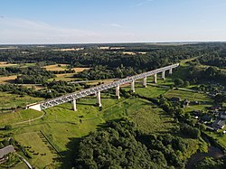
Lyduvėnai Bridge
Appearance
Lyduvėnai Bridge | |
|---|---|
 | |
| Coordinates | 55°30′22″N 23°5′8″E / 55.50611°N 23.08556°E |
| Crosses | Dubysa |
| Locale | Lyduvėnai |
| Official name | Lyduvėnų geležinkelio tiltas |
| Characteristics | |
| Total length | 599 m |
| Width | 4.5 m |
| Height | 42 m |
| History | |
| Opened | 1951 |
| Location | |
 | |
Lyduvėnai Railway Bridge (Lithuanian: Lyduvėnų tiltas) is one of the longest bridges in Lithuania.[1] It crosses the river Dubysa. It is located in Lyduvėnai, Raseiniai district.
References
[edit]- ^ Lyduvėnų geležinkelio tiltas (in Lithuanian)
