Lutovynivka
Appearance
You can help expand this article with text translated from the corresponding article in Ukrainian. (August 2018) Click [show] for important translation instructions.
|
Lutovynivka
Лутовинівка | |
|---|---|
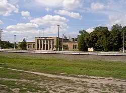
 Railway station in Lutovynivka (Hannivka) | |
| Coordinates: 49°14′N 33°54′E / 49.233°N 33.900°E | |
| Country Oblast Raion | Ukraine Poltava Oblast Kremenchuk Raion |
| Founded | 1923 |
| Area | |
• Total | 1 km2 (0.4 sq mi) |
| Elevation | 158 m (518 ft) |
| Population | |
• Total | 2,000 |
| • Density | 2,000/km2 (5,000/sq mi) |
| Time zone | UTC+2 (EET) |
| • Summer (DST) | UTC+3 (EET) |
| Postal code | 39100 |
| Area code | +380 5342 |
Lutovynivka (Ukrainian: Лутовинівка, Russian: Лутовиновка) is a small village, close to Kozelshchyna, in Kremenchuk Raion (district), Poltava Oblast (province) of central Ukraine, located 75 kilometres (47 mi) from Poltava. It belongs to Kozelshchyna settlement hromada, one of the hromadas of Ukraine.[1] The current estimated population is around 500 (as of 2012). Lutovynivka is also a railway station, and located close to the highway M22-E584.
Until 18 July 2020, Lutovynivka belonged to Kozelshchyna Raion. The raion was abolished in July 2020 as part of the administrative reform of Ukraine, which reduced the number of raions of Poltava Oblast to four. The area of Kozelshchyna Raion was merged into Kremenchuk Raion.[2][3]
References
[edit]- ^ "Козельщинская громада" (in Russian). Портал об'єднаних громад України.
- ^ "Про утворення та ліквідацію районів. Постанова Верховної Ради України № 807-ІХ". Голос України (in Ukrainian). 2020-07-18. Retrieved 2020-10-03.
- ^ "Нові райони: карти + склад" (in Ukrainian). Міністерство розвитку громад та територій України.


