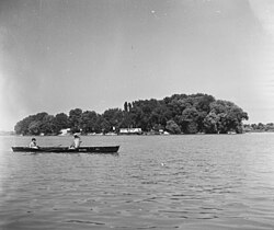
Lupa Island (Hungary)
Appearance
Native name: Lupa-sziget | |
|---|---|
 Lupa Island in 1955 | |
| Geography | |
| Location | Danube River |
| Coordinates | 47°36′58.1″N 19°05′9.4″E / 47.616139°N 19.085944°E |
| Administration | |
Lupa Island (Hungarian: Lupa-sziget) is an island on the Danube in Hungary. It is located on the Szentendre branch of the Danube, to the west of the much larger Szentendre Island and 14 kilometres (8.7 mi) to the north of the capital Budapest. It forms part of the town of Budakalász, in Szentendre District of Pest County.[1][2]
The island is inhabited, and there a number of houses on it. It is only accessible by boat.[1][2]
References
[edit]- ^ a b "47°36'58.1"N 19°05'09.4"E" (Map). openstreetmap.org. Retrieved 18 July 2019.
- ^ a b "Islands of the Danube around Budapest". 11 June 2017. Retrieved 18 July 2019.

